Two Strong Earthquakes Strike on the Same Day

Drake Passage and Papua Shaken on October 16, 2025

October 16, 2025 – Two Major Earthquakes Rock the Planet


On October 16, 2025, two separate strong earthquakes were recorded. One struck the Drake Passage between South America and Antarctica. The other hit near Papua, Indonesia.


Both events were confirmed by the U.S. Geological Survey (USGS) as strong and shallow, with magnitudes between M6.3 and M6.5.


Neither quake generated a tsunami. However, the twin events highlight how active the planet’s crust remains along major fault zones.

Summary

Two powerful earthquakes shook the Earth on October 16, 2025:

  • A M6.3 quake in the Drake Passage between South America and Antarctica.

  • A M6.5 quake near Papua, Indonesia.

Both quakes occurred within hours of each other and did not trigger tsunamis.
Together, they highlight the persistent seismic unrest along the Pacific Ring of Fire — a reminder of how dynamic and unpredictable our planet remains.


M6.3 Earthquake Strikes the Drake Passage

The first quake occurred at 01:42 UTC on Thursday, October 16. The Drake Passage is the rough sea channel separating South America from Antarctica. It is famous for strong winds but rarely experiences large earthquakes.


According to USGS, the quake measured magnitude 6.3 at a depth of 10 km (6.2 miles). EMSC reported a similar strength but at 20 km (12.4 miles) deep.
The epicenter was located about 686 km (426 miles) south of Tolhuin and 693 km (430 miles) southeast of Ushuaia, Argentina — the southernmost city in the world.


No tsunami warnings were issued. People at sea felt only light to moderate shaking.
USGS issued a Green Alert for potential casualties and damage, meaning that serious losses were unlikely.


Interestingly, this quake followed a M7.6 earthquake in the same region on October 10, 2025. That earlier event caused a temporary tsunami warning. The M6.3 tremor is therefore considered a strong aftershock of the major quake six days earlier.


M6.5 Earthquake Hits Papua, Indonesia

A few hours later, at 05:48 UTC, another powerful quake struck near Papua, Indonesia. This region lies along the northern edge of the Australian tectonic plate, where it meets the Pacific Plate.


The USGS reported a magnitude of 6.5 at a depth of 35 km (21.7 miles). Meanwhile, EMSC measured the quake at 11 km (6.8 miles) depth.
The epicenter was located around 200 km (125 miles) west-northwest of Jayapura and 270 km (167 miles) west-northwest of Vanimo, Papua New Guinea.


According to initial estimates, nearly 1.4 million people felt the shaking. About 23,000 experienced strong tremors and 22,000 moderate ones.
The Pacific Tsunami Warning Center (PTWC) confirmed there was no tsunami threat.


USGS also issued a Green Alert, suggesting a low probability of casualties or heavy damage.
However, shallow earthquakes in mountainous areas often lead to secondary hazards. Landslides or ground liquefaction could still occur, especially where soils are saturated or infrastructure is weak.


Why These Earthquakes Matter

Both earthquakes happened along the Pacific Ring of Fire, the world’s most active seismic zone. This region produces about 90% of all global earthquakes.


The Drake Passage lies at the boundary between the Antarctic and South American Plates. Meanwhile, Papua sits at the collision zone between the Australian and Pacific Plates.


Although neither quake caused major destruction, together they demonstrate how 2025 continues to be a year of high global seismic activity. Several M6+ and M7+ earthquakes have already occurred in October alone.

Read More

Iceland’s First Mosquitoes: Will They Survive?

For the first time in history, wild mosquitoes have been discovered in Iceland — a place long known as one of the few mosquito-free countries on Earth. The finding has surprised scientists and sparked...

How does La Niña affect the world in 2025?

La Niña is back! But what exactly is La Niña? Around the globe, climate patterns swing between two powerful forces: El Niño and La Niña. These events influence weather everywhere — from devastating...

Two Strong Earthquakes Strike on the Same Day

Two strong earthquakes struck on October 16, 2025 — a M6.3 in the Drake Passage and a M6.5 near Papua, Indonesia. No tsunami warnings were issued...

Heavy Rains in Mexico, Leaving Nearly 130 Dead or Missing

Heavy rains flood Mexican towns, leaving nearly 130 dead or missing

MEXICO CITY — October 15, 2025.


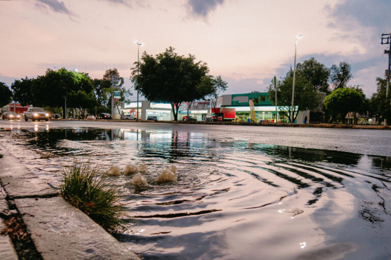
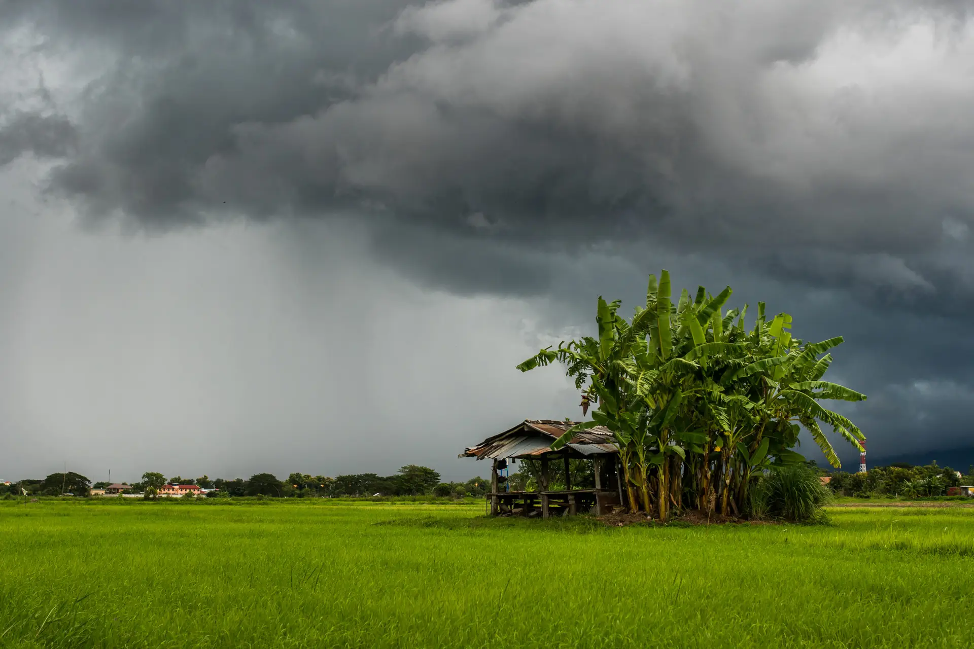
A tropical depression unleashed torrential rains across parts of Mexico’s Gulf Coast and central highlands, triggering deadly landslides and flash floods that have devastated communities and left nearly 130 people dead or missing.

The unnamed weather system struck toward the end of the rainy season, saturating land already soaked by months of precipitation. Rivers burst their banks and hillsides collapsed under the weight of the water, even as meteorologists’ attention was focused on other tropical storms and two hurricanes moving along the Pacific coast.


According to Mexico’s national civil protection agency, at least 64 people have been confirmed dead and 65 others remain missing as of Monday. “This intense rain was not expected to reach such magnitude,” President Claudia Sheinbaum told reporters.


Around 100,000 homes have been damaged or destroyed, Sheinbaum said, adding that she would meet with the Ministry of Finance to coordinate reconstruction funds and visit several of the hardest-hit states later this week.


Hidalgo and Veracruz suffered the most severe impact, with 29 deaths and 18 missing reported in Veracruz and 21 deaths and 43 missing in Hidalgo, said Laura Velázquez, the national coordinator of Civil Protection. Landslides in mountain regions buried homes, blocked roads, and isolated dozens of towns.


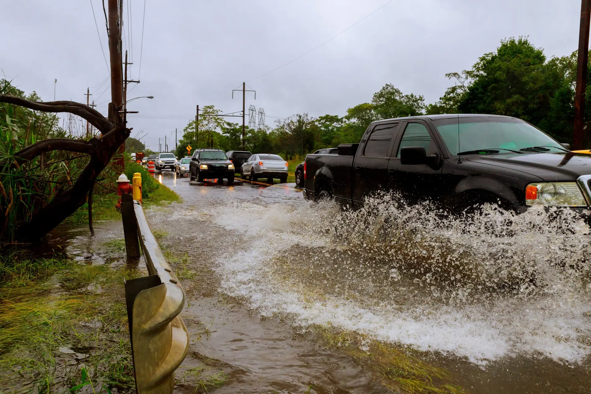
Infrastructure across at least five states has been heavily damaged. Bridges collapsed, roads washed away, and entire neighborhoods were left under thick layers of mud. Dramatic footage shared online showed emergency responders wading through chest-deep water to rescue stranded residents and deliver food and medical supplies.


Electricity, which had been knocked out in large areas across Veracruz, Puebla, and Hidalgo, has now been largely restored, officials said. Efforts are also underway to contain outbreaks of mosquito-borne illnesses such as dengue, which often spread after flooding due to stagnant water.


The federal government has deployed thousands of soldiers and emergency workers to the affected regions as the search for survivors continues. Authorities have warned that more rain is expected in the coming days, potentially complicating rescue and recovery operations.


Read More


Uncategorized

Heavy rains flood Mexican towns, leaving nearly 130 dead or missing


October 15, 2025

Uncategorized
Heavy rains flood Mexican towns, leaving nearly 130 dead or missing MEXICO CITY — October 15, 2025. A tropical depression unleashed torrential rains across parts of Mexico’s Gulf Coast and central…
Queensland bushfire warning issued after unusually hot weather

News

Queensland bushfire warning issued after unusually hot weather


October 7, 2025

News
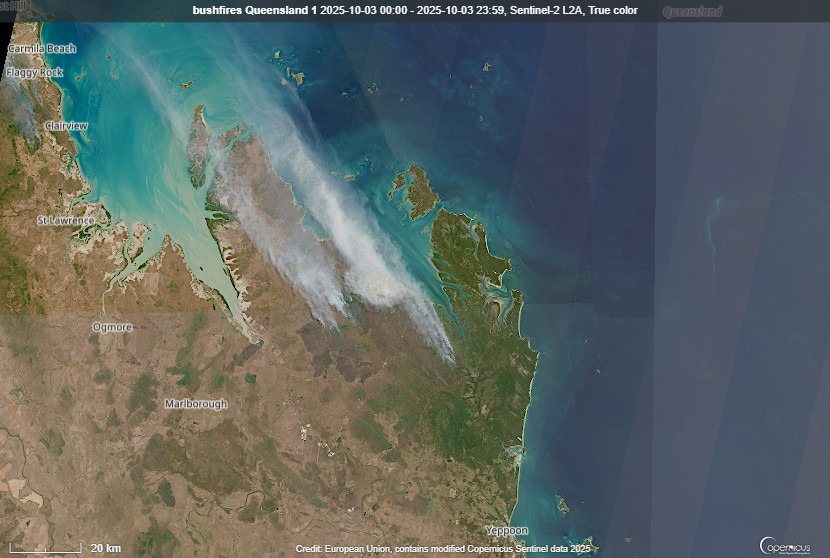
Record-breaking October heat has sparked dozens of Queensland bushfires, forcing evacuations and testing firefighters early in the season. Authorities say the early fires fit forecasts for a…
Why monsoon rains have been so unusual heavy this year

Climate change,News

Why monsoon rains have been so unusual heavy this year


October 1, 2025

Climate change,News
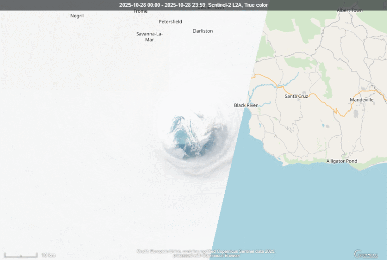
The 2025 monsoon is shifting from southwest to northeast after one of the wettest seasons in years. Discover why it was so intense and what comes next…

Queensland bushfire warning issued after unusually hot weather

More than 70 active fire incidents across Queensland amid unusually hot October temperatures

Tuesday 7 October 2025

QUEENSLAND, AUSTRALIA – Firefighters have responded to more than 100 incidents across Queensland as unusually hot October temperatures sparked an early start to the bushfire season.


Townsville recorded its hottest October day in 67 years on Friday, reaching 36.4°C by mid-morning. Meteorologists say the early outbreak of fires is consistent with La Niña conditions expected to develop later this year, which typically bring increased inland heatwaves and rainfall variability.

Firefighters tackle Brisbane bushfire

On Friday, the Queensland Fire and Emergency Services (QFES) issued a Not Safe to Return notice for residents near a slow-moving bushfire west of Brisbane, with a Watch and Act warning covering Mount Nebo Road, Betts Road and Camp Mountain Road.
The alert was later downgraded to Stay Informed, and police revoked an emergency declaration under the Public Safety Preservation Act (PSPA).


More than 20 crews remained on site with three water-bombing aircraft providing aerial support.


Speaking to ABC Radio Brisbane shortly after 5:30 p.m. on Friday, QFES Assistant Commissioner Matt Bulow said he was concerned about the days ahead.

“There’s been significant progress, but it’s still not over yet. In that area, there are a lot of hot spots,” he said.
“We’re going to have crews in and around that area not just all night tonight but for the next couple of days.”

The fire began earlier in the week and jumped containment lines due to soaring temperatures, gusty winds and low humidity.


Evacuation at Cape Palmerston National Park

In northern Queensland, almost 100 people were evacuated from campsites in Cape Palmerston National Park, about an hour south of Mackay, on Friday.
Police and state rangers used the National Park booking system to ensure all visitors were accounted for.

Billy O’Grady, Principal Ranger for the Central West, said conditions remained concerning.

“We do have some drier, windier weather persisting over the weekend and into next week,” he said.

Townsville records hottest October day since 1958

Hot air masses pushed northwards through the state, with Townsville hitting 36.4°C — the city’s hottest October day since 1958, when the mercury reached 37.1°C.


It marks Townsville’s second-hottest October day on record.


Elsewhere, the heat has eased across central and southern Queensland following record-breaking temperatures on Thursday.
The Bureau of Meteorology (BOM) said slightly cooler conditions are expected over the weekend.

“We’re expecting sunny days ahead across the state, but a little bit of relief in the temperatures,” said BOM meteorologist Jordi Cairol.


La Niña outlook

The early onset of bushfires this year aligns with forecasts for a developing La Niña event by late 2025.
While La Niña usually brings wetter conditions to eastern Australia, it can also drive intense inland heatwaves and volatile weather patterns.


The U.S. National Oceanic and Atmospheric Administration (NOAA) is expected to release its next ENSO (El Niño–Southern Oscillation) update on October 9, which could confirm the transition to La Niña 2025/2026.

Read more...

Iceland’s First Mosquitoes: Will They Survive?

For the first time in history, wild mosquitoes have been discovered in Iceland — a place long known as one of the few mosquito-free countries on Earth. The finding has surprised scientists and sparked...

How does La Niña affect the world in 2025?

La Niña is back! But what exactly is La Niña? Around the globe, climate patterns swing between two powerful forces: El Niño and La Niña. These events influence weather everywhere — from devastating...

Two Strong Earthquakes Strike on the Same Day

Two strong earthquakes struck on October 16, 2025 — a M6.3 in the Drake Passage and a M6.5 near Papua, Indonesia. No tsunami warnings were issued...

Why monsoon rains have been so unusual heavy this year

Why monsoon rains have been so unusual heavy this year

 According to the India Meteorological Department (IMD), the southwest monsoon finally began its withdrawal on September 24, 2025. The moisture-laden winds that drenched India for months are gradually giving way to drier, cooler air from the northeast. 


But this year has felt different: the monsoon was stronger than usual, with torrential rains, widespread flooding, and devastating landslides. How did this happen, and what does the shifting wind direction mean for the months ahead? Text continues belows the video. 


For a deeper dive into how the Asian monsoon works, check out our detailed explainer video:

An Exceptionally Wet Southwest Monsoon

The 2025 southwest monsoon has been one of the wettest in recent years. Across India, rainfall was about eight percent higher than the long-term average. In states such as Punjab and Himachal Pradesh, totals were more than forty percent above normal. The impact was severe: villages were submerged, farmland was damaged, and rivers burst their banks. Beyond India, the heavy rains also hit Pakistan, Nepal, and parts of Southeast Asia. Deadly floods forced mass evacuations and disrupted daily life. In the Himalayas, hundreds of extreme rainfall events were recorded, the highest number in the past five years.


Why Was the Monsoon So Intense?

Several factors explain why the 2025 season turned out so fierce. Sea surface temperatures in the Bay of Bengal and the Arabian Sea were warmer than usual, adding extra moisture to the atmosphere. This fueled stronger and more persistent storms. Climate change amplified the effect, since a warmer atmosphere can hold more water vapor, which increases the chance of extreme downpours. On top of that, a series of low-pressure systems over the Bay of Bengal slowed the withdrawal of the monsoon. As a result, the wet period lasted longer and the damage increased.


The Shift Toward the Northeast Monsoon

Now the southwest winds are retreating, and weather patterns across Asia are beginning to shift. Northern and central India are moving into a cooler and drier phase. In southern India, however, the arrival of the northeast monsoon marks the start of the region’s most important rainy season, bringing water that the southwest monsoon often fails to deliver. In the Philippines, the same wind shift signals the arrival of Amihan. This period is known for cooler, drier air that replaces the hot and humid conditions of Habagat. Yet the Bay of Bengal remains at risk. Tropical cyclones can still form in October and November, releasing heavy rainfall and destructive winds.


What Lies Ahead

The transition of the monsoon is much more than a meteorological curiosity. It shapes food production, public safety, and the lives of hundreds of millions of people. After an exceptionally wet summer, communities now prepare for a new season. The balance is shifting from relentless rainfall to cooler and drier conditions. Still, the long-term outlook is uncertain. A warming climate continues to alter both the intensity and the predictability of the monsoon, raising urgent questions for the future.


Read more...

The Subtropical Question – More on Oceanic and Humid Subtropical Climates

New York is Subtropical. Really? According to the Koppen Climate Classification, it has the same Humid Subtropical Climate as New Orleans in the Deep South. Sounds crazy, doesn’t it? And what...

Microclimates – Sudden climatic shifts over just a few miles

Microclimates – dramatic shifts in temperature, rainfall or both over just a few kilometers or miles. How are these sudden shifts possible. In this video I look at the five basic types of...

Seasons – Origin and Variation Across Earth. Types Of Seasons by Climate Zone

Seasons – Origin and Variation Across Earth. Types Of Seasons by Climate Zone There are various types of seasons on this earth, determined by which climate zone one is in. In this video, I will...