Venice: The city that is slowly sinking and flooding

The sinking city of Venice, Italy

Venice, the city of canals and gondolas, is one of the most breathtaking and unique places in the world. Built on 118 small islands in the Venetian Lagoon, it has long been a historical and cultural icon, attracting millions of visitors every year. However, this remarkable city is facing a growing crisis—Venice is sinking and flooding at an alarming rate. But what exactly is causing this? Here are the eight major factors responsible for the city’s gradual descent into the water.


  1. Natural Land Subsidence

Venice is built on soft sediment layers composed of sand, silt, clay, and organic material. Over time, these layers naturally compact due to their own weight and the pressure exerted by the city’s buildings. This process, known as land subsidence, causes Venice to sink at a rate of approximately 1 to 2 millimeters per year.


  1. Heavy Buildings and Infrastructure

The magnificent buildings of Venice, constructed from stone and brick, put additional strain on the city’s delicate foundations. Because Venice was built on wooden piles driven into the sediment, the uneven weight distribution leads to structural imbalances, cracks, and further subsidence. The more construction and restoration efforts take place, the more pressure is added to the city’s already fragile foundation.


  1. Mass Tourism and Overcrowding

Venice is one of the world’s most visited cities, receiving millions of tourists every year. The overwhelming number of visitors, combined with construction activities to support tourism, puts significant pressure on the city’s infrastructure. Bridges, public spaces, and water systems experience wear and tear, accelerating structural damage and increasing maintenance costs.


  1. Tectonic Movements

Venice is also affected by geological forces beneath the surface. The shifting of the Adriatic Plate and the Apennine Mountains contributes to the natural subsidence of the city. These slow-moving tectonic shifts alter the stability of the lagoon’s sediment layers, increasing the likelihood of minor tremors and structural weakening.


  1. Groundwater Extraction

During the early to mid-20th century, groundwater extraction was a major cause of Venice’s sinking. Industries in the nearby Marghera area, as well as the city’s growing population, demanded large amounts of water. As water was pumped out, the soil beneath Venice started to compact more rapidly, accelerating subsidence. By the late 1960s, authorities recognized the damage and significantly reduced or stopped groundwater extraction to slow down the sinking process.


  1. Acqua Alta – Seasonal High Tides

One of the most visible and immediate threats to Venice is Acqua Alta, the temporary flooding that occurs mainly in autumn and winter. Acqua Alta is caused by a combination of factors:

  • Spring tides during full or new moons amplify gravitational forces, raising water levels.
  • Strong scirocco winds from the Sahara push water northward into the Adriatic Sea and Venetian Lagoon.
  • Low atmospheric pressure reduces the force pressing down on the sea, allowing water levels to rise.

When these factors align, severe flooding can inundate the city, causing disruptions and damage to historic structures.


  1. Extreme Weather and Climate Change

Climate change is making Venice’s flooding problems worse. More frequent and intense storms, heavy rainfall, and rising temperatures contribute to higher water levels in the lagoon. When combined with Acqua Alta and strong winds, these conditions increase the severity and frequency of floods, putting Venice at greater risk.


  1. Rising Global Sea Levels

Perhaps the most alarming factor in Venice’s future is global sea level rise caused by climate change. As polar ice caps melt and ocean temperatures increase, sea levels continue to rise. Higher water levels make high tides even more extreme, leading to frequent and severe flooding. If global warming continues unchecked, Venice’s future as a livable city may be in jeopardy.


Can Venice Be Saved?

With all these threats, is there a solution to save Venice? While the answer is complex, several efforts are being made to protect the city.


MOSE Flood Barrier System

The MOSE system with the city on the left and the sea on the right.


The MOSE system is Venice’s most ambitious flood protection project. This system consists of 78 mobile barriers installed at lagoon inlets to block rising tides, such as Acqua Alta, from flooding the city. Initially planned for completion in 2011, the project faced numerous delays, budget overruns, and political scandals. However, it became operational in 2020, with final completion expected soon. MOSE can protect Venice from tides up to 3 meters (10 feet), safeguarding critical areas like Piazza San Marco.


Additional Measures

Besides MOSE, Venice has implemented other flood mitigation efforts:

  • Elevating infrastructure such as streets and public spaces.
  • Improved drainage systems and water pumps.
  • Water-resistant restoration techniques for historic buildings.
  • Sediment management in the lagoon to maintain water balance.
  • Regulations on large ships to prevent further erosion.
  • Climate adaptation strategies to prepare for future changes.

The Future of Venice

The fight to save Venice is ongoing. While technological solutions like MOSE and improved infrastructure provide hope, the city’s survival ultimately depends on long-term strategies addressing climate change and responsible tourism. Public awareness and global efforts to combat rising sea levels are crucial to ensuring that Venice remains a cultural treasure for generations to come.

Venice’s story is a cautionary tale about the delicate balance between nature and human intervention. As we admire its beauty, we must also recognize the urgent need to protect it.

The unique man-made climate of New York City

The unique man-made climate
of New York City

It may surprise many that NYC is classified as humid subtropical under the Köppen climate system—despite its famously snowy winters. This unique classification comes from a complex mix of natural geography and intense urban development. From towering buildings to endless pavement, human activity has reshaped the city’s climate dramatically. In this article, we’ll explore how New York’s weather is defined, how it compares to surrounding areas, and what role the urban heat island effect plays in shaping daily life. Whether you’re a local, a visitor, or a climate enthusiast, you’ll gain a fresh perspective on NYC’s ever-changing weather.


Understanding the Köppen Climate Classification

The Köppen climate classification system was developed by German climatologist Wladimir Köppen to group global climates based on temperature, precipitation, and seasonal patterns. New York City falls into the Cfa category, which stands for humid subtropical. This type of climate is typically associated with hot, humid summers and relatively mild winters without a dry season.


Interestingly, parts of NYC also exhibit traits of the Dfa classification—humid continental—characterized by greater seasonal temperature differences, including colder winters. However, due to human influence and geographic factors, the city remains officially categorized as Cfa.


How Urbanization Impacts NYC’s Climate

New York City’s classification as a humid subtropical zone is significantly influenced by its dense infrastructure. Without this urban sprawl, NYC might shift toward the humid continental category. The presence of concrete, steel, and human activity raises average temperatures, particularly at night and during the winter months. This phenomenon, known as the urban heat island effect, traps heat within the city, preventing the kind of deep freezes common in more rural areas nearby.


The difference becomes most noticeable during winter. While cold winds from Canada regularly sweep through the region, the city remains 2 to 3 degrees Celsius warmer on average than surrounding towns. This added warmth helps maintain its subtropical status.


Climate Zones Around NYC

Just beyond the five boroughs, the climate begins to change. Northern suburbs and parts of upstate New York fall into the Dfa category, with colder winters and lower humidity. In contrast, areas like Long Island and the Hudson Valley often retain the Cfa classification due to their coastal exposure and, in some cases, the extended reach of the urban heat island.


While urbanization is a major factor in NYC’s climate, geography also plays a role. The nearby Atlantic Ocean moderates extreme temperatures, and NYC’s relatively low elevation further contributes to its mild winter profile.


Rainfall and Seasonal Precipitation

New York City experiences rainfall throughout the year, with no true dry season. On average, annual precipitation reaches about 1,250 millimeters (50 inches). Spring tends to be the wettest season, while February is typically the driest, although every month sees at least some rain. This consistent precipitation supports a diverse range of urban greenery and contributes to the city’s changing seasonal moods.


Storms are common, particularly during summer when warm, moist air masses from the south clash with cooler air from the north. These encounters often produce sudden, intense rainfalls, accompanied by thunder and lightning.


Summer in NYC: Heat, Humidity, and Haze

Summers in New York are characteristically warm and often uncomfortably humid. Daily highs frequently exceed 30°C (86°F), and the humidity can make the air feel even warmer. Although cooling breezes occasionally drift in from the Atlantic, they often aren’t enough to offset the trapped heat from the city itself.


Most summer winds arrive from the southwest, carrying warm, moist air into the metropolitan area. Heat waves, sometimes lasting several days, are increasingly common and can strain the city’s energy grid while creating health risks for residents—especially the elderly and those in underserved neighborhoods.


Winter Weather: Cold, but Moderated

Winters in New York are cold, but not as frigid as those in interior northeastern states. January and February bring the lowest average temperatures, often dipping below freezing. Still, the city is relatively insulated from the worst of the cold thanks to both urban heat and the nearby Atlantic.


Snowfall is a regular occurrence, but the city’s warmer ground temperatures and salty sea air often turn it quickly to slush. Blizzards do happen—especially when Atlantic moisture meets cold, continental air—but they are generally more disruptive than long-lasting.


Transitional Seasons: Spring and Fall

Spring in New York typically begins with cool temperatures in March and gradually warms through April and May. It’s often marked by rainy days and sudden temperature swings. By late spring, the weather turns pleasant and green spaces throughout the city burst into bloom.


Fall starts off warm and gradually cools toward the winter months. September and early October can feel like an extension of summer, but by November, jackets are essential. Autumn is also peak season for hurricanes and tropical storms. A vivid example of this was Hurricane Sandy in 2012, which made landfall in late October, causing massive flooding, power outages, and long-term infrastructural damage across the five boroughs.


Why NYC’s Subway Heats Up in Summer

One of the most extreme examples of the urban heat island effect can be felt underground. During summer, the New York City subway becomes intensely hot, often exceeding 40°C (104°F) on platforms and in tunnels.


The combination of train air conditioners releasing heat, insufficient ventilation, and radiated warmth from pavement above creates a stifling environment. Despite improvements in modern train cooling systems, station design continues to challenge temperature control, making the subway one of the city’s least comfortable places in summer.


Extreme Temperatures in NYC’s History

New York City’s climate range is wide. The hottest recorded temperature was 41°C (106°F) in 1936, while the coldest plunged to -26°C (-15°F) in 1934. These extremes reflect NYC’s position between temperate and continental zones, as well as the changing influence of global climate trends.


While such temperatures are rare, recent years have shown an increase in weather volatility, with more frequent heat waves and unseasonal snowfalls, reinforcing concerns about long-term climate change.


Climate Change and the City’s Future

In 2019, NYC became one of the first U.S. cities to declare a climate emergency. This bold move reflected growing concerns over rising sea levels, more frequent extreme weather events, and increased heat-related illnesses.

Forecasts suggest the city could face up to 57 days annually above 32°C (90°F) by mid-century—up from around 18 days today. Annual precipitation is expected to increase by 13%, and sea levels are projected to rise by about 3 cm (1.2 inches) per decade.


In response, the city is investing in adaptive infrastructure: building seawalls, reinforcing subway tunnels, expanding green roofs, and improving emergency response systems. These efforts aim to future-proof a city already grappling with the realities of a warming world.


Conclusion: A Climate Shaped by City and Sea

New York City’s climate may officially be labeled “humid subtropical,” but the full story is far more complex. It’s a dynamic balance between natural forces and human design, geography and infrastructure, Atlantic winds and urban heat. The Köppen classification offers a useful lens, but the lived experience of NYC’s climate is as layered and unique as the city itself.


Whether it’s a snowstorm in February or a blazing subway platform in July, the city’s weather continues to challenge, surprise, and define daily life for millions.

Living in the Fog: Lima, Peru’s Unique Climate Explained

The City of Fog:

Discover the Amazing Climate of Lima, Peru

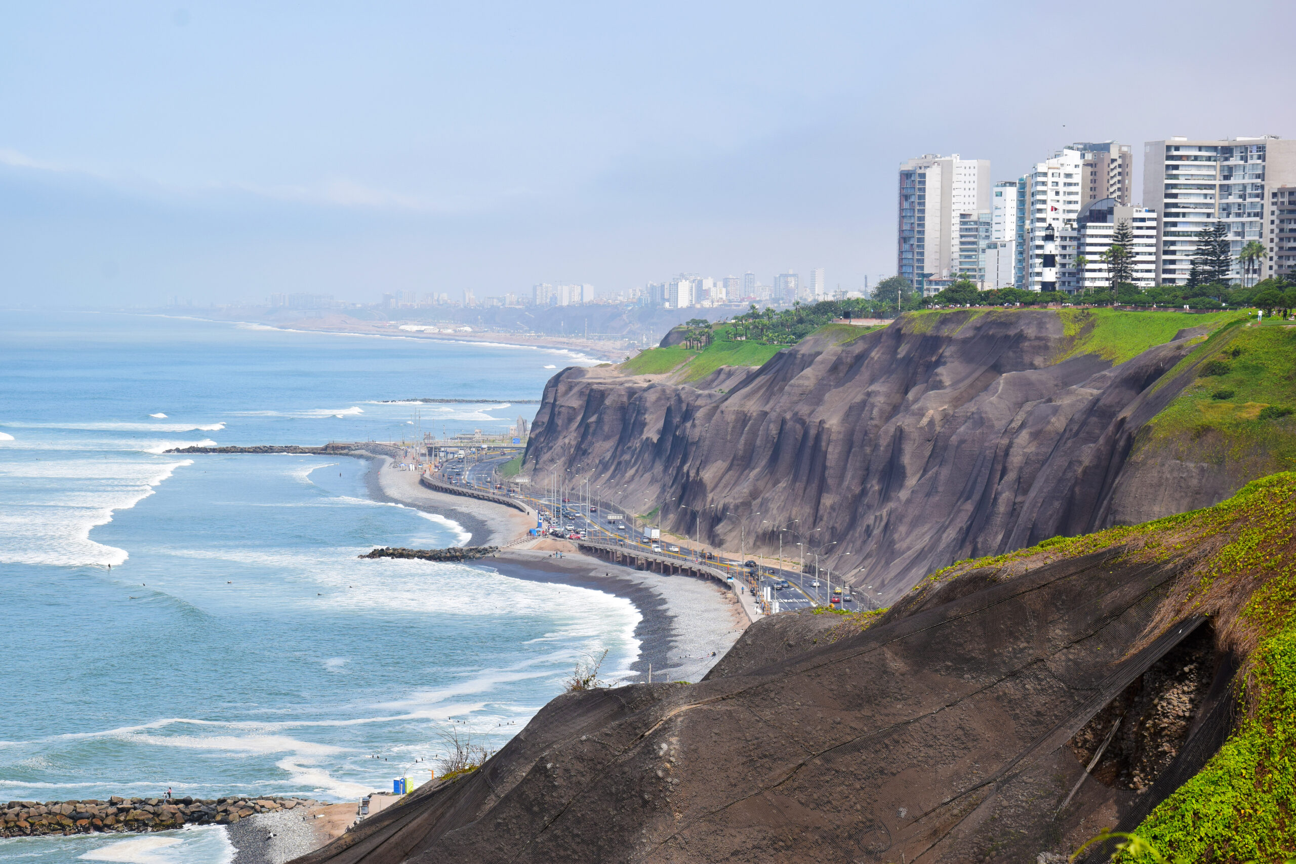
Lima, Peru’s capital city with over 10 million residents, lies uniquely between towering Andes mountains and the vast Pacific Ocean. Known for its rare tropical desert climate, Lima surprises with mild temperatures, persistent fog, and almost no rain. Discover why Lima’s climate is unlike any other city in the world.


Lima’s Origins and Tropical Location

Founded in 1535 during the Spanish conquest, Lima is Peru’s capital and sits at just 12°S latitude, placing it deep within the tropics. It spans the Pacific coast, enclosing a population exceeding 10 million in its metropolitan area. Despite its tropical position, the city receives virtually no rain, a stark contrast to other tropical metropolises. Lima instead experiences persistent high humidity, frequent low clouds and fog, and extremely dry weather overall.


Why Tropical Deserts Are Rare—and Why Lima Is One

Most deserts around the world belong to one of two categories: hot subtropical deserts, found just outside the tropics (beyond 23° latitude), and cold deserts, found inland or in mountain rain shadows. Tropical deserts—especially major urban ones—are nearly unheard of. Lima defies these norms thanks to two key factors: the Andes mountains and the Humboldt Current.


The Andes: Blocking the Rainy Season

To the city’s east, the Andes soar above 6,300 m (20,000 ft), acting as a natural barrier to moist trade winds arriving from the equatorial Pacific during the summer. Without them, Lima would experience a classic tropical savannah pattern: a defined wet season followed by a dry one. Instead, the Andes block that moisture entirely, leaving the city dry year-round.


The Humboldt Current: Cooling the Tropics

Parallel to the coast flows the cold Humboldt (or Peru) Current, which brings frigid waters from the mid-latitudes toward the equator. Near Ecuadorian borders, water temperatures hover around 16 °C, roughly 10 °C cooler than expected for a tropical latitude. This dramatically cools the air above the ocean, which shapes Lima’s unusual climate.


Mild Temperatures and Persistent Fog

Thanks to the cool current, Lima’s coastal climate stays mild. Winters see lows around 14 °C, not the typical low twenties of the tropics, while summers average 26 °C, rather than surpassing 30 °C. With relative humidity often above 80%, moist air and fog blanket the city—especially in winter. Lima is, in fact, one of the cloudiest cities globally, logging just 1,230 sunshine hours annually—which is half what cities like Bangkok enjoy.


Why Lima’s Humidity Doesn’t Rain

To understand why humidity doesn’t translate into rain here, recall that warm air holds more moisture than cool air. Rain requires air to rise, cool, and condense—either via storm systems or by being lifted over mountains. However, Lima’s daytime land temperatures, heated by tropical suns, remain warmer than the cool ocean. Any fog or moisture that drifts inland quickly evaporates. Without uplift, Lima’s clouds remain shallow, turning to fog rather than rainfall.


Result: A Never-Raining Tropical Desert

The combination of the rain-blocking Andes and cold Pacific waters creates exceptionally stable atmospheric conditions. The water droplets in Lima’s sky simply don’t collide and grow large enough to become rain. As a result, Lima sits firmly in the BWh (Hot Desert) category of Köppen’s classification: “B” for dry, “W” for desert, and “h” indicating a mean annual temperature above 18 °C. Though some sources have playfully suggested an unofficial “BWn” label for “mild desert,” this is not recognized in peer-reviewed climate studies.


Desert Cities and Water Solutions

Lima isn’t the only city built in a desert, but being in the tropics makes it unique. Despite its arid conditions, the city has managed to grow steadily, thanks to water sourced from Andean springs and rivers, pumped down into the basin. Meanwhile, more remote coastal communities have turned to innovative methods: they install fog nets, which condense moisture from coastal fog into drinkable water—an ingenious workaround to the city’s lack of rainfall.


Conclusion: A Climate Shaped by Nature and Geography

Lima defies expectations—a sprawling tropical metropolis in a near-rainless desert climate. The towering Andes shut out rain-bearing winds, while the cold Humboldt Current chills the coast. The result is a city cloaked in fog, bathed in mild air, and rich in water ingenuity despite its desert classification. Lima’s climate is a masterclass in geography, meteorology, and human adaptation.