Planet Earth. Our home. Among all the worlds in the universe, it’s the only one we know that harbours life. A spinning globe of blue, green, gold and white. A thing of beauty. But for many of us, a thing of questions. Many of these concern that thing which impacts us every day of our lives – the weather.
In this global age, so many of us have travelled beyond our own borders, to lands that were hotter, colder, drier or wetter than our own. Or perhaps even gone half way around the world, and yet experienced weather very similar to the country of our origin. And perhaps some of us asked the question, why is this so?
Climate Graphs from Various Koppen Climate Zones
All these questions have been answered, and they all come under one subject. That of CLIMATE.
Climate is defined as “The weather conditions prevailing in an area in general or over a long period.”
While in one region, it might rain one day, and be sunny the next, or cool one week, and hot the next, it’s the long term pattern of rainfall and temperature, day after day, which will determine how that region will look, whether it will become a desert, or support grasslands or even forests in their many different forms.
And, more importantly, in our human-centred world, these patterns of moisture and temperature will determine what crops can be grown or what livestock can be supported, to feed ourselves.
It has shaped the rise and fall of empires… And last but not least, climate has shaped even the way that we look, ourselves, as humans.
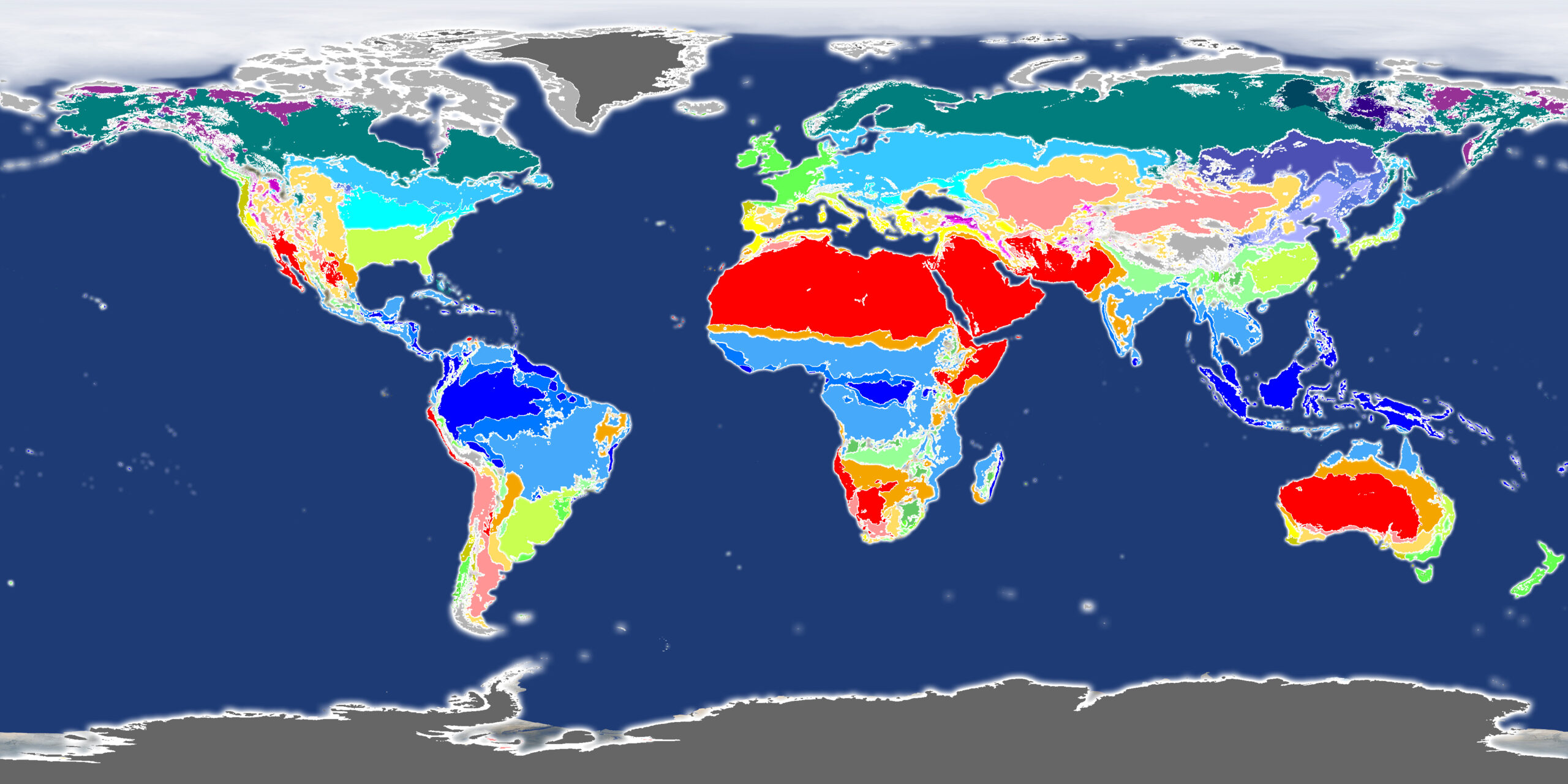
The secret code of our planet’s various climates was cracked long ago by the founder of modern climatology, Wladimir Koppen. He developed a system based around observation of vegetation in different parts of the world, and how the rainfall and temperature varied in these regions throughout the year. And he broke them down into five broad categories of climate which roughly started at the equator and moved out toward the poles. These run like this:
Tropical
Dry
Temperate
Continental
Polar
Tropical Climate Zones
Dry Climate Zones
Temperate Climate Zones
Continental Climate Zones
Polar Climate Zones
With later refinements, these broad categories were further categorised into additional sub-categories based on distribution of rainfall and temperature through a full year, to give us the Koppen-Geiger Climate Classification system of today.
In this series, we’re going to take a look at each of these different climate types, showing you real places in the world where they exist, why they are that way, and revealing the exact climate type that each and every major world city lies in.
So if you want to know what to wear on your next holiday, or… you really do want to learn more about our world, then this series is for you.
Coursework Questions
Define the term “climate” in your own words, and how it differs from the word “weather”.
Name a climate zone that exists in both the northern and southern hemispheres and on different continents, and the countries or regions involved.
Who is considered to be the father of modern climatology?
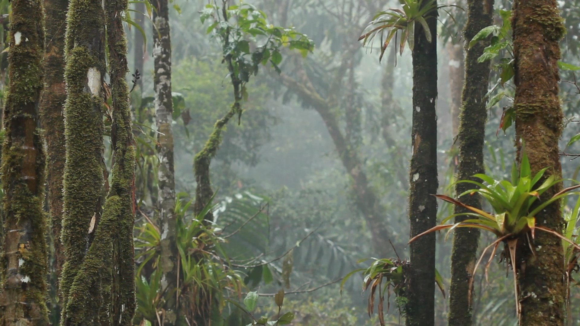
Imagine a place with no seasons. Where every day seems like the last. A place where it rains almost every day. A place of constant heat, and humidity. Some might call such a place a hell, while for others, it might be paradise.
It is a place on earth with more species of plants and animals than anywhere else. Because of the oxygen generated by its millions of trees, it has been dubbed the lungs of the world.
You have arrived at the band encircling the centre of the Earth. Welcome to the Tropical Rainforest.
Description and Dynamics
We begin our journey through Earth’s climate zones here, because here is the very centre of the Earth, the equator.
And it is no accident that such a hot and wet climate exists on the equator, because it is here that the sun is strongest, striking the earth directly at 90 degrees. And as it does so, it causes the hot air to rise, pulling in moisture from the surrounding seas.
Intense sunlight strikes the equator at or around 90 degrees
Surface heating produces thermals, inrush of moist air, rising to form clouds
As this humid air rises up into the high atmosphere, it cools. But cool air cannot hold onto moisture like warm air can, and so that moisture precipitates out into vast, towering thunder clouds, which then finally release as torrential rain.
And it is because of its central position, on the equator, that little to no change in temperature is experienced throughout the year. While more northerly and southerly latitude experience the colder and hotter seasons, life on the equator is about watching the sun drift slightly north and slightly south of being directly overhead. In any position, it is still beating down, producing that heat, and the thermals that produce all that rain.
Sun angle at the equator in March
Sun angle at the equator in June
Sun angle at the equator in September
Sun angle at the equator in Decemeber
There is more complexity to this of course… some areas on the equator experience wet and dry seasons, but we’ll cover and explain this more in the following chapter, which concerns the Tropical Monsoon and Tropical Savannah.
Global Distribution of the Tropical Rainforest Climate
Where in the world do we find the Tropical Rainforest Climate?
So where in the world can we find these forests? Well, naturally, they’re all within the tropical zone. The most famous of these is of, course, the Amazon river basin of South America which stretches across many countries most notably Brazil, Peru, Colombia, Ecuador, Venezuela and the Guyanas. The Pacific Coast of Colombia on the other side of the Andes mountains is also home to this climate. And then there’s the Congo basin of Africa mostly within the country of the Congo Zaire, but also including parts of Uganda. The last of the three main rainforest zones is in South-East Asia, with almost all of Indonesia and Malaysia falling within this climate type, along New Guinea and the southern and eastern stretches of the Philippines. Many islands of the Pacific experience the same climate, including the Solomon Islands, Fiji and French Polynesia.
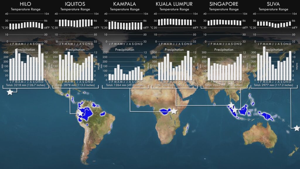
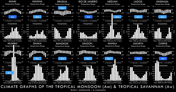
So enough chatter – I know you’re all dying to see some temperature and rainfall graphs, right? Well here they are, across three continents and oceans, all remarkably the same. High and almost unchanging temperature throughout the year, and high rainfall throughout the year with no dry seasons.
Climate Graphs for the Tropical Rainforest Climate
We should mention something about the graph of Hilo in Hawaii. At almost 20 degrees north of the equator, it’s pretty far from it, and yet still possesses a very wet and warm climate. The year-round rainfall is due to it being on the windward side of the large volcanoes on the Big Island of Hawaii. North-easterly winds, known as trade winds, blow moist warm air off the Pacific all year round, and when this moist air hits the mountainous slopes, it rises, cools and dumps huge amounts of rain upon the city.
There are some other parts of the tropics where this Trade Wind Coast variant of the Tropical Rainforest climate is found, including the Caribbean coasts of Central America and some Caribbean islands, including the Dominican Republic and Puerto Rico as well as some eastern coastal areas of Brazil and Madagascar. There will be more on the trade winds in the next couple of chapters – they are key also to explaining the patterns of wet and dry seasons in other parts of the tropics.
Landscapes, Vegetation and Land Use
So, what kind of vegetation do we find here? Well… tropical rainforest, funnily enough. But what is it? Rainforests occur in other parts of the world – forests that grow in areas of very high rainfall. But the tropical rainforest has a unique combination of high rainfall and high temperature, which results in the most vigorous plant growth to be found anywhere on the planet.
This growth most notably occurs in the form of evergreen hardwood trees, meaning dense, hard wood, like mahogany, teak, sandalwood and rosewood. But unlike the hardwoods of more temperate latitudes, these trees retain their leaves, and grow, all year round. A diverse array of plants grow in the shade below the thick tree canopy, and this further leads to a huge number of animal species in all classes – insects, arachnids, amphibians, reptiles, birds and mammals. Spend a night in a tent here and… well you’ll soon get to know some of these guys.
Tropical Rainforest in French Guiana, South America
Palm oil plantation in Indonesia
And what about agriculture? Crops that favour the year round rain and high temperatures include two of the world’s favourites – bananas and coconuts, and they have been farmed commercially in these regions for a century or more, primarily for export to the developed world. More recently, the demand for palm oil, which has favourable properties for use in cooking, has increased considerably, leading to controversial clearing of rainforests, especially in Malaysia and Indonesia.
Agriculture throughout history, and across the world has always been the principal enemy of forests. But at this time, with so much global attention on the importance of maintaining the biodiversity of the tropical rainforests, finding an equitable solution between this and the economic livelihood of the people that live in these regions seems elusive as ever.
Notable Cities
Lastly, we come to major world cities. Are any found in the tropical rainforest? Well only two feature, and these are just hours apart from each other on the southern tip of Malaysia. Kuala Lumpur, the capital of Malaysia and famous for the Petronas Towers… and Singapore, a highly developed global financial, shipping and aviation hub.
Coursework Questions
How does the temperature and rainfall distribution vary throughout the year in the Tropical Rainforest climate, and why is this?
What is the Koppen Climate Classification code for this climate?
Why does so much rain fall in this climate?
List out some regions, countries and cities where this climate zone occurs.
Explain what is meant by the “Trade Wind Coast” variant of this climate.
What type of natural vegetation occurs in this climate?
What is meant by “biodiversity”, and how does it relate to this climate?
Describe some of the challenges that habitats are facing in these regions.
For so many of us in the developed world, the seasons are defined by temperature. The freshness of spring, the heat of summer, the chill of autumn and the cold of winter. But for the billions of people on our planet that live in the tropics, the seasons are marked by the presence, and absence, of rain. The annual coming of the rains after months of drought, with the renewal of life from the giving water… And then, after months of rain and cloud, the sun reborn into blue skies as the next dry season begins.
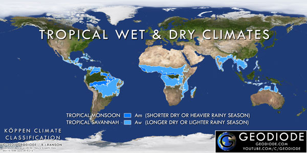
This is the domain of the tropical wet and dry climates. This is the Tropical Monsoon, and the Tropical Savannah.
Description and Dynamics
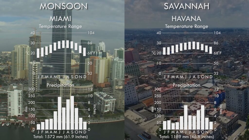
Monsoon areas are overall wetter or have a shorter dry season, Savannahs are drier overall or have a longer dry season.
In the last chapter we looked at the Tropical Rainforest climate zone, where rain occurs throughout the year. But most of the lands in the tropics experience some kind of drought, or reduction in rainfall during the year. The severity of this drought and the total amount of rain that falls in a year determines whether it comes under the classification of Monsoon or Savannah. Monsoon areas are overall wetter or have a shorter dry season, Savannahs are drier overall or have a longer dry season.
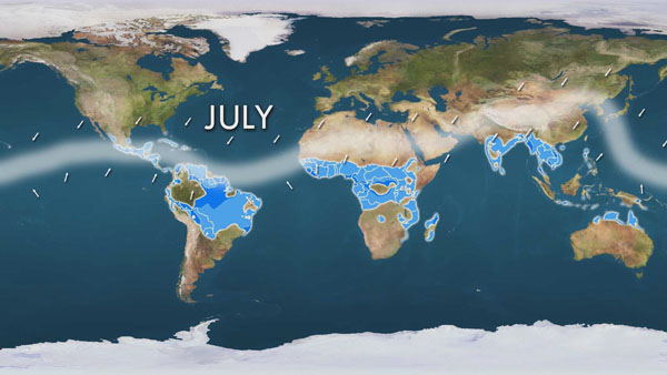
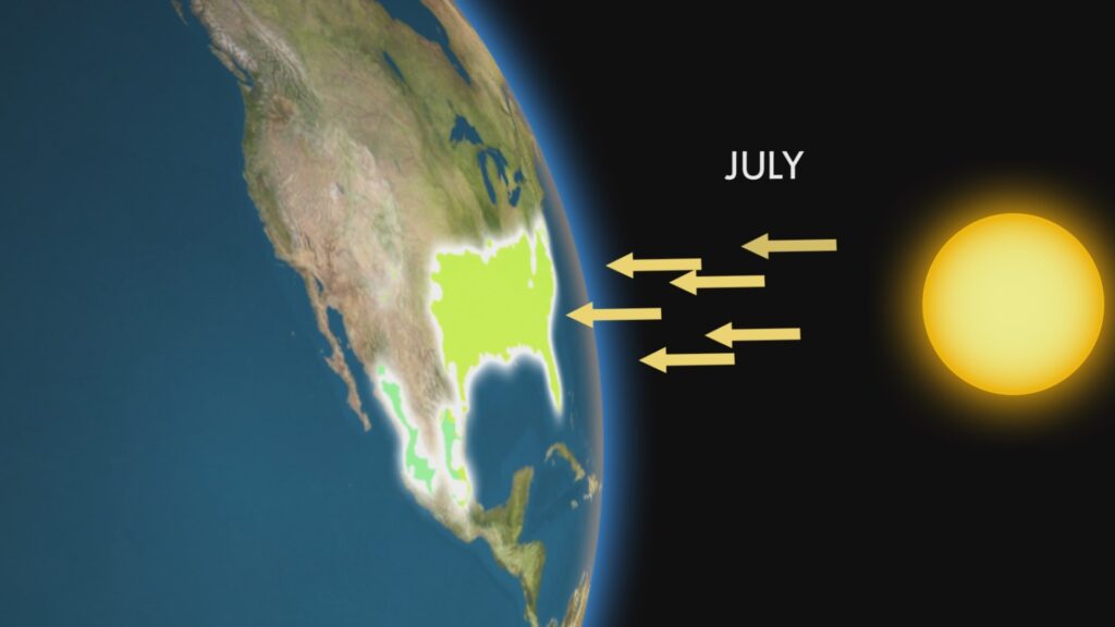
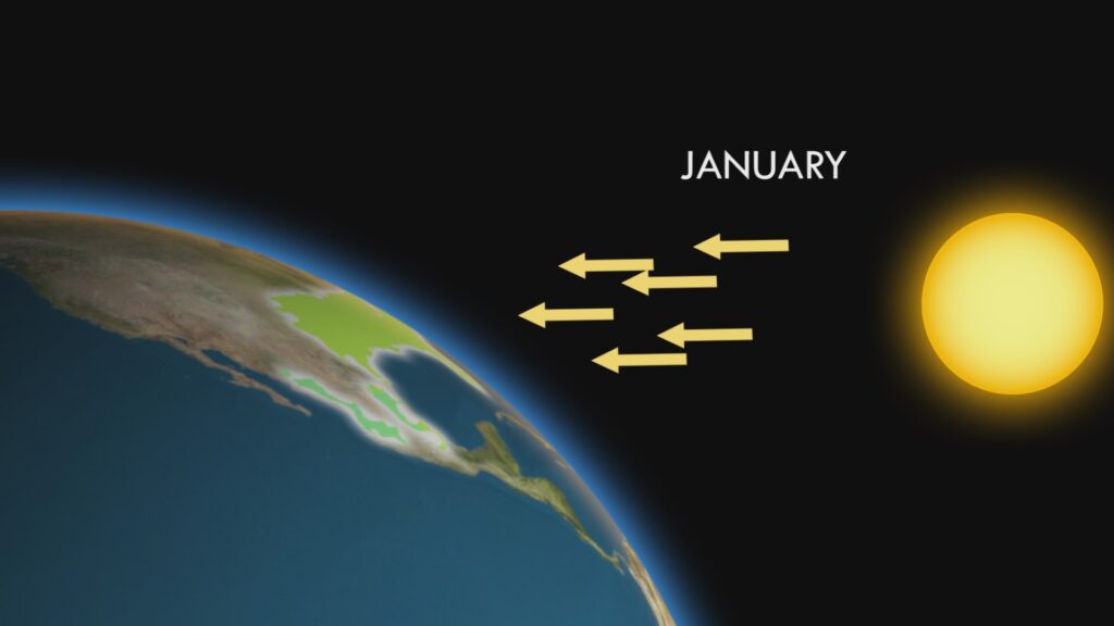
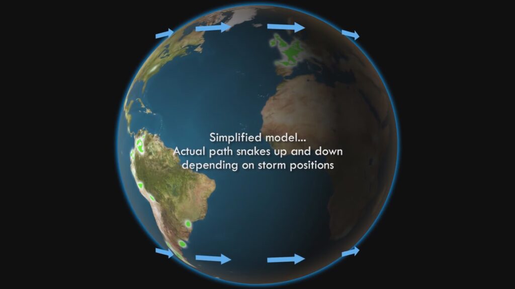
So what accounts for this variation in rain? In the tropics, the sun will be directly above you at noon at some point in the year. And if the sun is directly above, it means it’s heating that part of the earth more than any other, and that means rising air, the pulling in of moist air from the surrounding seas and oceans, and lots of rain. The band of the earth, where these winds come together has for centuries been called The Doldrums by sailors, because there is very little wind at this confluence, and could lead to weeks or even months of being stranded in a sailing ship. The rains follow this band as it tracks the sun above and below the equator throughout the year. In July, it’s summer in the North, so this band is located to the north of the equator, while in January it is at its furthest extent south of the equator. A more scientific term for the Doldrums is the Inter Tropical Convergence Zone (“ITCZ”).
Approximate position of Doldrums (ITCZ) in July
Approximate position of Doldrums (ITCZ) in January
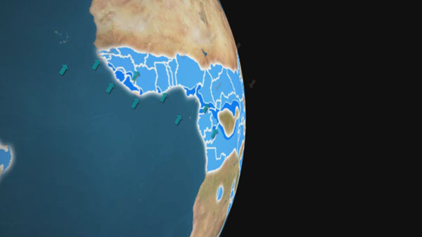
The winds which come into this convergence are called the trade winds, named by those same sailors of centuries past, since they were so predictable, sailing ships could count on them to ply their trade. In the tropical wet and dry climate zones, these winds switch direction depending on whether the doldrums are to the north or south. When they originate from the ocean, they bring moisture, and rain. But when they come from the land, they are bone dry, and bring nothing to the land.
Trade winds in summer come from the ocean and bring rain
Trade winds in winter come from the land and are dry
Landscapes, Biomes and Agriculture
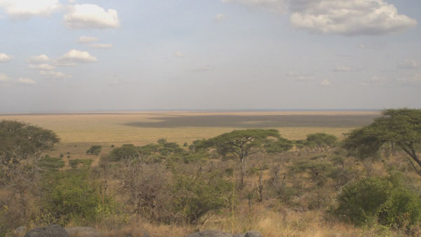
So what kind of landscapes do we find in these regions? Depending on the severity or longevity of the dry season, we can find anything from tropical forests to open grasslands. On the wetter side of this spectrum, we find the much of the jungle of the Amazon and South-East Asia. But such forests do not have as rich a biodiversity as the Tropical Rainforest. As the rainfall reduces the further out we go, we find less dense, drier forests mixed with grasses, the Savannah itself.
Mixed trees and grasslands landscape that is the definition of savannah
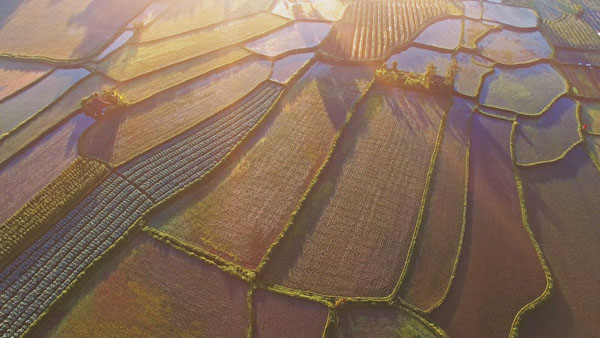
Rice paddies landscape in Asia
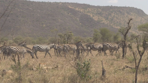
A herd of zebra on the African savannah
The tropical grasslands of Africa are perhaps some of the most iconic landscapes in the world. Here, the biodiversity of the Tropical Rainforest is exchanged for huge numbers of large herbivorous animals that trek for hundreds of miles each year to follow the rains and the green grass that feeds their vast numbers. And they themselves are followed by world famous predator species, who don’t want to let all that walking food go to waste.
Much of South-East Asia and India is given over to the production of rice, which excels in this climate, producing two or more harvests each year. Such productivity is one reason why Asian nations have such large populations compared to other parts of the world.
In Central America, the Caribbean and Brazil, sugar cane is the most famous of world crops that has dominated these areas for centuries. While in West Africa, we find much of the land given over to cocoa production. So… one could say we can thank the Savannah climate for that most favourite of foods – chocolate.
Global Distribution of the Tropical Wet & Dry Climate Zones
Where in the world do we find the Tropical Monsoon and Tropical Savannah Climate Zones?
So where in the world do we find the tropical wet and dry seasons? In the tropics, obviously, that is, between 23 degrees north and south of the equator.
Starting in the Americas, this zone encompasses the southern tip of Florida, much of southern Mexico, and most of Central America and the Caribbean. Large tracts of Venezuela, Brazil and lowland Bolivia are given over to savannah and tropical forest, and this climate zone accounts for almost half of all land area in South America, such is its extent.
In Africa, we find practically all of the West and Central African nations under the Savannah, along with Tanzania, Mozambique and Madagascar in the south east.
In Asia, most of southern India, Bangladesh and Sri Lanka is in this climate zone. The famous monsoon western coast of India experiences the most extreme wet and dry seasonal variation in the world, as you’ll see in the upcoming city graphs.
All of Burma, Thailand, Laos and Cambodia live within these zones, along with most of Vietnam and the Philippines.
Lastly, the northern coasts of Australia experience the monsoon at the opposite time of year to its more famous Indian brother.
So we talked about all those billions of people living in this climate zone. Well, most of these live in developing countries, and yet, we find enormous cities here. Some of these are world famous. Here are the biggest and brightest.
Coursework Questions
What causes the Doldrums (or ITCZ) and why do they move across the tropics throughout the year?
What are trade winds and what is their relationship to tropical wet and dry seasons?
What are the Koppen codes for these climates? How do they differ from each other?
What types of natural landscapes do we find in regions with tropical wet and dry climates? What exactly is savannah?
How important are these regions for agriculture? List out some crops that grow here.
List out some countries, regions and cities that experience tropical wet and dry climates.
There are places on this planet, where altitude and latitude combine to form a harmonious, temperate balance. High in the clouds of the tropics, there is an escape from the humidity and heat of the forests and plains below. These mountains, valleys and plateaux are places of flourishing cities, breath-taking beauty and the setting of unique cultures and history. Defined by their special climate, these are the world’s Subtropical Highlands.
Description and Dynamics
So far in this series, we’ve been looking at the hot and humid climates of the tropics – the Rainforest, the Monsoon and the Savannah. Before we leave the tropics and head to greater latitudes, however, there is one final type of climate here that we cannot overlook, and that is the one in the highland regions near the equator.
The relation between temperature and altitude
As one increases in altitude, the temperature of the air decreases – this is evident to anyone who looks up at a high mountain and sees snow on its summit. But in the tropics, where the temperature at sea level is high, there is a wide band of altitudes that produce mild and pleasant temperatures all year round.
This year-round mildness is unique among all world climates, and has made these regions attractive for human settlement throughout history, offering increased comfort, and avoidance of tropical diseases, such as malaria.
There are two variations within the Koppen Climate Classification, distinguished by rainfall patterns.
The first, Cwb, is the most common, and this is basically a high-altitude cooler version of the Tropical Monsoon and Savannah climates that we covered in the last chapter. It is characterised by a distinct wet and dry season.
The other, Cfb, is, like the first, a cooler high altitude equivalent of a lowland tropical climate, in this case, the Tropical Rainforest. With Cfb we find no dry season, and rain all year round. It is a quirk of geography, we find this climate very similar to that of the Oceanic climate of Britain and North-West Europe, in that it is cool and moderate, with rain all year round. More, much more about that one in a future chapter.
Subtropical Highland climate with no dry season (Cfb) is simply a high-altitude form of Tropical Rainforest (Af)
Dry Winter Subtropical Highland climate (Cwb) is simply a high-altitude form of Tropical Savannah (Aw)
Where in the world do we find the Subtropical Highland Climate Zones?
The Inca ‘Lost City’ of Machu Picchu in Peru, is found within a Subtropical Highland climate
So where in the world do we find the Sub-Tropical Highlands? In terms of latitude they between the Tropics of Cancer and Capricorn – 23 degrees north and south of the equator. And these areas are high up, usually between 1500 and 4000m (5,000 to 13,000 feet).
Starting in the Americas, we find the densely populated central valley of Mexico, home to that country’s capital and mega city of the same name, and once home to the Aztec Empire. Onto South America, and Colombia and Ecuador are the two countries that are dominated by the rarer Cfb variant of the Subtropical Highland climate that gives year-round rain. Almost all of the major cities in these countries are packed into the high valleys of the Andes that run through this area, including the capitals of Bogota and Quito. Heading further south, we encounter the highlands of Peru and Bolivia, once the home of the Inca Empire and now home to the highest capital city in the world – La Paz. Last in this continent is a highland area in a small part of Southern Brazil around the city of Curitiba.
Global Distribution of Subtropical Highland Climate Zones
Moving across now to Africa, and almost all the lands within this climate zone follow a line north to south along the huge Rift Valley that dominates the eastern part of this continent. Starting in the north and we find the heart of Ethiopia and its capital Addis Ababa. As we head south, we encounter the high plains of Kenya and its capital Nairobi. Parts of Uganda, Congo, Burundi, Rwanda and Tanzania intersect this climate where the lands rise up high enough. Much of Malawi, Zambia and Zimbabwe are high enough to experience this mild climate, including all these countries’ capital cities. At the southern tip of the continent, we find the north eastern heart of South Africa coming within this climate zone, including that nation’s capital of Pretoria, and its largest city, Johannesburg. And if all that wasn’t enough we find another capital, that of the island of Madagascar, also living within this mild climate.
The last continent to experience the Subtropical Highland climate is Asia, where, in the southern foothills of the Himalayan mountains, altitudes are in the sweet spot to provide an all year round spring to Kashmir in northern Pakistan, the northern extremes of India, much of Nepal, including its capital Kathmandu, and a large swathe of Yunnan Province in south-west China. A razor-thin part of New Guinea, almost on the equator, but with altitudes in excess of 4,000m, also experiences year-round mild temperatures.
Plants in the highlands around Mount Kenya (Image courtesy of Milosh Kitchovich)
Landscapes, Biomes and Agriculture
So what kind of landscapes and agriculture do we find in the subtropical highlands? Well, that depends upon altitude, and how much rainfall we see.
In uncultivated land, the lower reaches are covered in either thick forests, such as the well-known “cloud-forests” of the Andes that are extensions of the Tropical Rainforest, or grasslands that are merely extensions of the Savannah, most notably in Africa. Higher up we find unusual plants specifically designed to withstand the higher altitudes, and are unique to this climate.
When it comes to land cultivated by humans, we find spectacular landscapes carved out of the hillsides – terraced farming in abundance, rice in Asia in the present day, and corn in the once-Inca Empire of South America.
And the most remarkable fact I’ve saved until last. Because the Subtropical Highland climate has two very special plants. One produces a leaf, another a bean. Each of these makes up a drink, and between them they drive our working world. They are probably the most widely drunk beverages throughout the globe. I’m talking, of course, about tea and coffee, and they’re uniquely suited to this climate, not growing easily anywhere else.
Notable cities with Subtropical Highland Climates
Notable Cities
Being an escape from the tropical heat of the equatorial regions, it’s no suprise that we find many large and well-known cities here, including numerous national capitals. The adjacent image shows the most notable of these with their climate graphs.
Coursework Questions
What happens to air temperature when one rises in altitude? What effect would this have on a tropical climate?
What are the Koppen codes for Subtropical Highland climates? How do they differ from each other?
What types of natural landscapes do we find in regions with Subtropical Highland climates?
What are the two world-famous crops that grow well only in this climate?
List out some countries, regions and cities that experience Subtropical Highland climates.
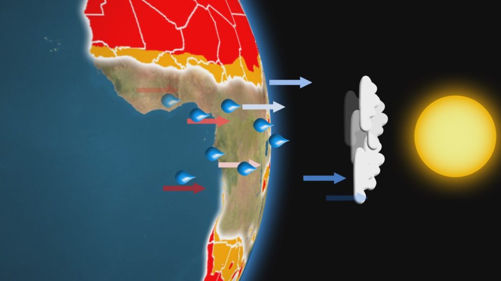
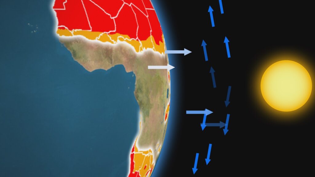
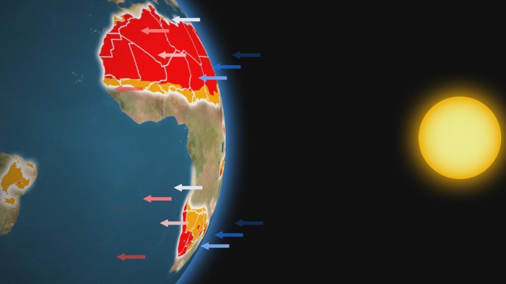
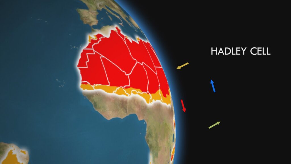
As we transition away from the equator and move toward the poles, we pass through one of Earth’s most extreme climate zones: the hot deserts. But why do these dry, sun-scorched bands exist at all?
The answer lies in the atmospheric circulation patterns that govern global climate. Near the equator, the Sun’s energy heats moist air, causing it to rise rapidly into the upper atmosphere. As this air ascends, it cools, and its moisture condenses, falling as heavy rainfall. This process is what fuels the tropical rainforests.
But what happens to the air after it releases its moisture? It doesn’t disappear. It moves away from the equator, toward the subtropics. Eventually, it begins to descend—typically around 30° north and south latitude. This sinking air has already lost most of its moisture and now warms as it compresses under increasing atmospheric pressure.
This descending, dry air creates regions of high pressure, where the sky remains mostly cloudless. The lack of clouds allows intense solar radiation to reach the surface, producing scorching temperatures during the day. At the same time, the dry air holds onto any remaining moisture, so rainfall becomes extremely rare.
Solar heating near the equator produces thermals that lose their moisture as rain
Tropical uplift of air must go somewhere so it moves out toward the poles
The now dry air from the tropics falls down in subtropical areas that, denied rain, lead to deserts
This entire cycle of rising and falling air is part of a global circulation pattern known as the Hadley Cell. The Hadley Cell explains not only the formation of hot deserts, but also the climates of tropical rainforests, savannas, and monsoon regions. It’s one of the key systems that shapes weather and climate in the tropical and subtropical parts of the world.
It’s worth noting that not all deserts form this way. Some, like the Atacama or Gobi, are classified as cold deserts and arise from entirely different processes—topics we’ll explore in later chapters.
The Hadley Cell of Tropical and Subtropical air circulation explains Tropical Rainforest, Tropical Wet & Dry and Hot Desert climates
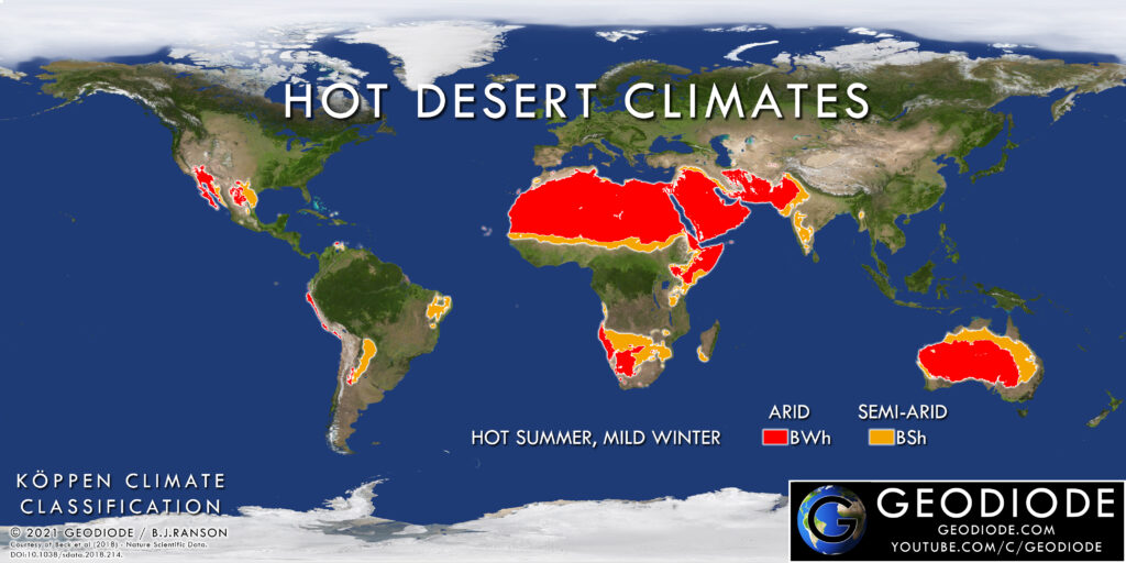
Climate Patterns and Köppen Classifications
Hot desert climates are not all the same, but they do share some defining features. The Köppen Climate Classification System divides them into two main types, based primarily on how much rain falls annually:
BWh (Hot Desert): These areas receive the least rainfall, often less than 250 mm per year.
BSh (Hot Semi-Arid): These regions receive slightly more precipitation—enough to support scattered shrubs and grasses, but not forests.
Both climates are marked by extreme heat, particularly during the long summer months. Because rainfall is rare, the seasons in hot deserts are defined by temperature, not by wet or dry periods. Typically, there are two main seasons: a long, extremely hot summer, and a shorter, mild or cool winter.
How much temperatures fluctuate from summer to winter depends largely on two factors: latitude and distance from the ocean. The further a desert is from the equator or a large body of water, the greater the seasonal variation in temperature.
For example, Baghdad—located at 33° north latitude and far from any coastline—experiences scorching summers and chilly winters. In contrast, Mogadishu, which lies near the equator and sits on the coast of the Indian Ocean, maintains fairly stable temperatures year-round.
Another important trait of desert climates is the dramatic drop in temperature at night. With no moisture in the air and few clouds, heat escapes quickly after sunset, resulting in chilly nights—even after blisteringly hot days.
These conditions help shape not only the landscape and vegetation but also how humans adapt to life in the world’s driest environments.
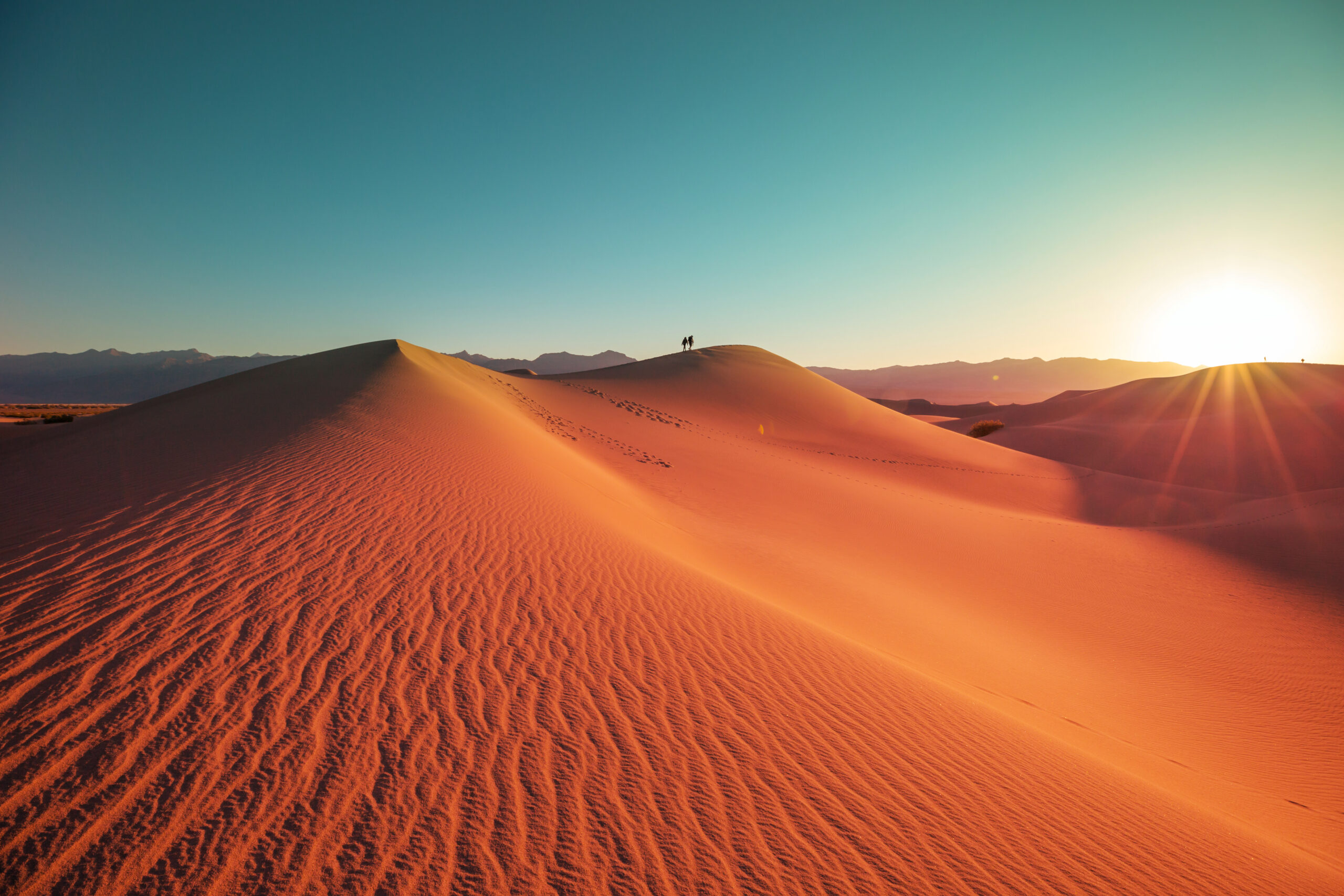
Global Distribution of Hot Desert Climate Zones
Where in the World Do We Find the Hot Desert Climate Zones?
Hot desert regions are found across multiple continents. Let’s explore their global distribution:
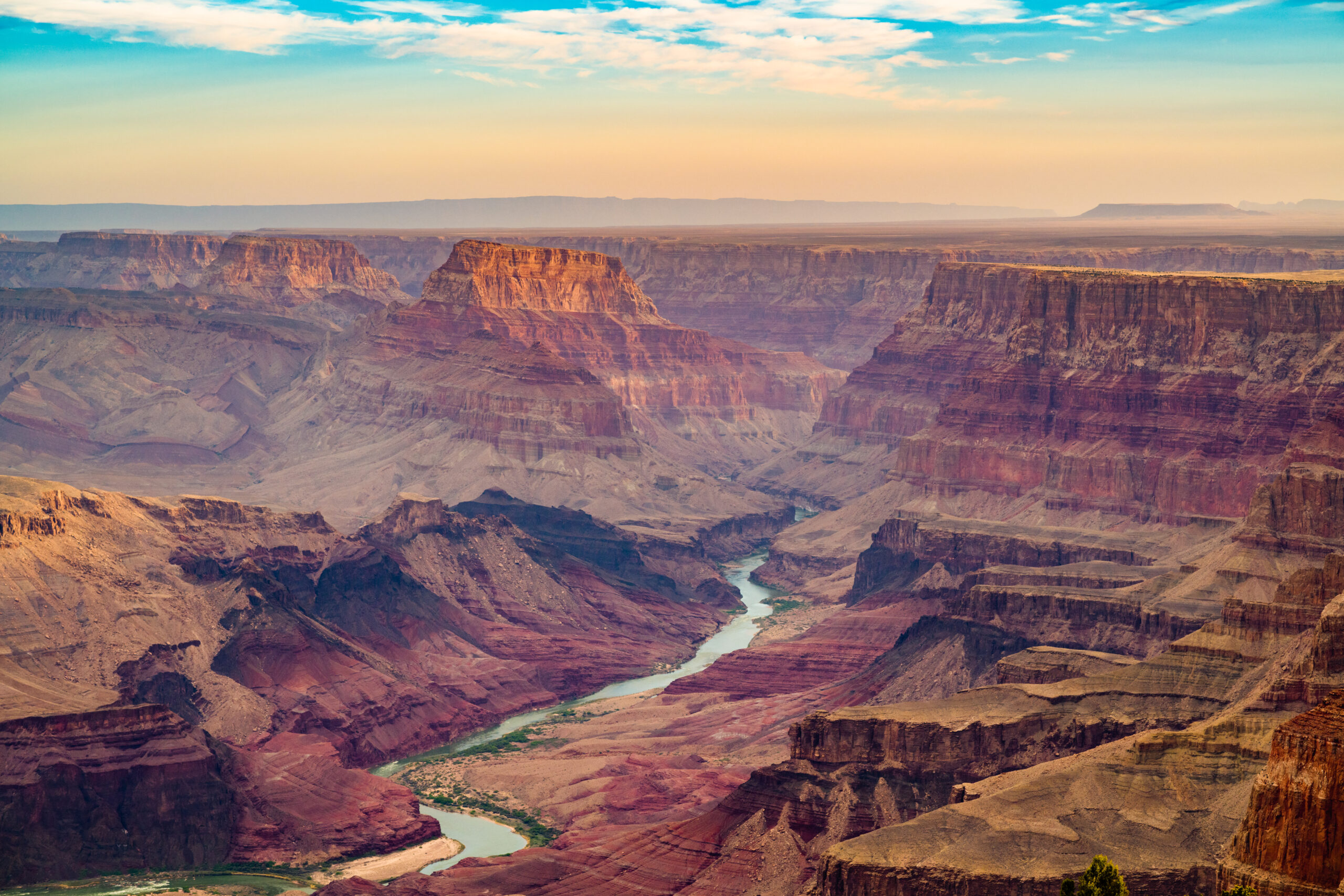
North America: The Mojave Desert in the southwestern United States spans parts of California, Nevada, and Arizona. It extends into Mexico as the Sonoran Desert, including the Baja Peninsula. The Chihuahuan Desert lies in northeastern Mexico.
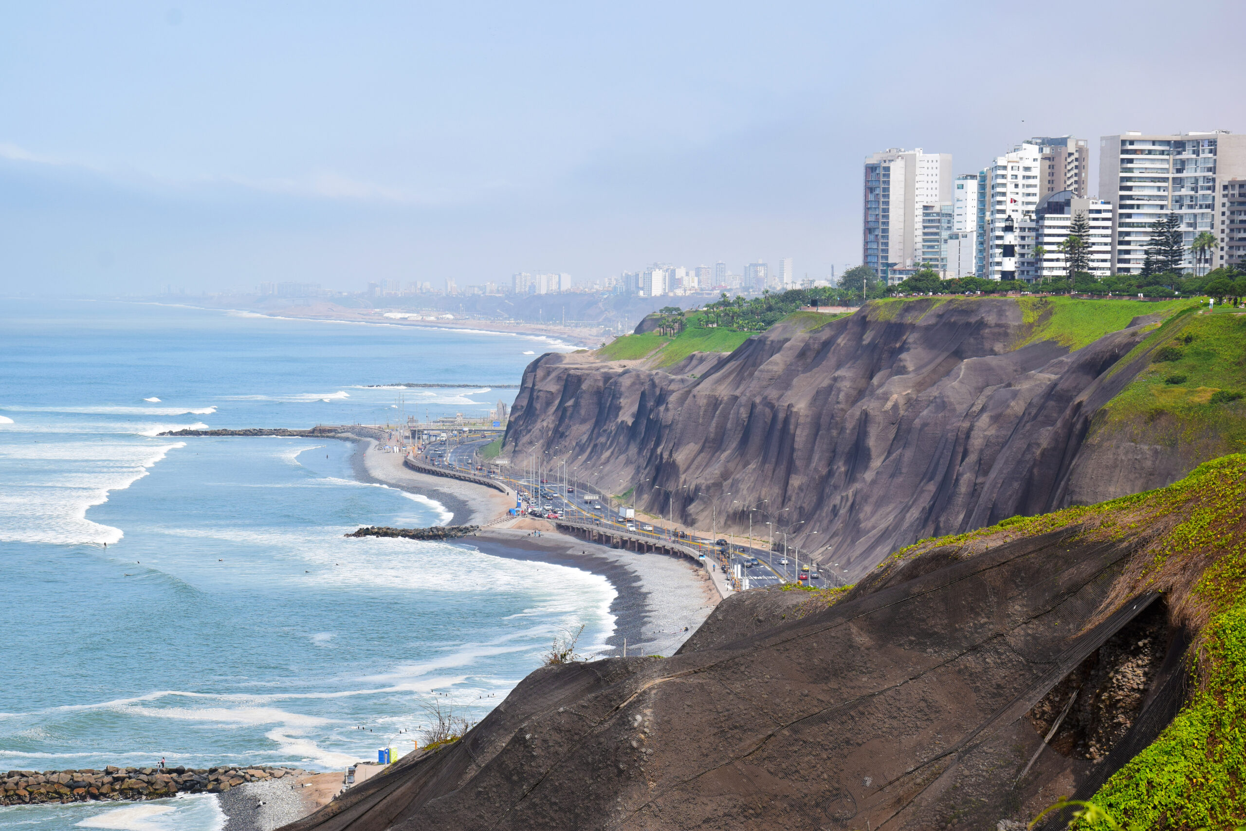
South America: The coast of Peru is one of the driest regions on Earth, often shrouded in fog due to cold ocean currents. Inland lies the Chaco of northwestern Argentina.
Africa and the Middle East: The Sahara Desert dominates northern Africa and is the largest hot desert in the world. It stretches eastward into the Arabian Peninsula, parts of Iran, Pakistan, and reaches the Thar Desert in western India. In southern Africa, the Namib Desert—also foggy in coastal areas—leads into the Kalahari Desert.
Australia: Most of the continent is covered by arid or semi-arid land. This includes named deserts like the Great Sandy, Great Victoria, and Gibson Deserts, forming the “Red Heart” of Australia.
These deserts are shaped not only by latitude but also by ocean currents, altitude, and continental placement.
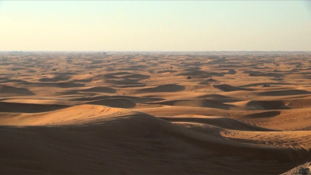
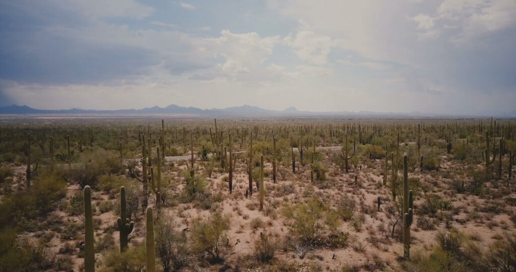
Landscapes and Biomes
The landscapes of hot deserts are defined by minimal vegetation, which exposes the Earth’s rocky surface and dry soils. These raw, open environments give us a glimpse into the geological foundations of our planet.
Because there are few plants to hold soil in place, winds often grind exposed rock into fine sand. These sands form towering dunes, which can shift and grow over time. Other areas consist of bare rock, cracked earth, or gravel plains.
Where some moisture exists, plants have adapted with incredible efficiency. Hardy shrubs are spaced out to reduce competition, and cacti dominate the scene in some deserts. These plants are uniquely designed to store water for long periods, survive intense heat, and even withstand years between rainfalls.
Sand dunes in Dubai
Cacti in Arizona
Notable Cities
Despite the harsh conditions, many major cities thrive in hot desert regions. Thanks to modern infrastructure, water management, and trade, these urban centers support millions of residents.
Climate graphs of notable cities in Hot Desert climate regions
Coursework Questions
How does the uplift of tropical air at the equator relate to the formation of hot deserts in subtropical regions?
What is the Hadley Cell and what role does it play in determining various climatic conditions in tropical and subtropical regions?
Explain why hot deserts, despite being at higher latitudes, can have higher temperatures than equatorial regions.
Why is it that some coastal areas of hot deserts feature frequent fogs?
What are the Köppen codes for these climates? How do they differ from each other?
What types of natural landscapes do we find in hot deserts?
Name five hot deserts and describe their location.
List out some countries and cities that experience hot desert climates.
A full course for beginners to climate science, covering in detail every climate zone of earth. Includes the full video for each climate zone, in addition to the full script, for reference, along with...
Planet Earth. Our home. Among all the worlds in the universe, it’s the only one we know that harbours life. A spinning globe of blue, green, gold and white. A thing of beauty. But for many of us, a...
Imagine a place with no seasons. Where every day seems like the last. A place where it rains almost every day. A place of constant heat, and humidity. Some might call such a place a hell, while for...
For so many of us in the developed world, the seasons are defined by temperature. The freshness of spring, the heat of summer, the chill of autumn and the cold of winter. But for the billions of...
There are places on this planet, where altitude and latitude combine to form a harmonious, temperate balance. High in the clouds of the tropics, there is an escape from the humidity and heat of the...
Hot Deserts (4) https://www.youtube.com/watch?v=itnYTE-3u-o&embeds_referring_euri=https%3A%2F%2Fwww.geodiode.com%2F&source_ve_path=MjM4NTE Atmospheric Origins of Hot Desert Climates As we...
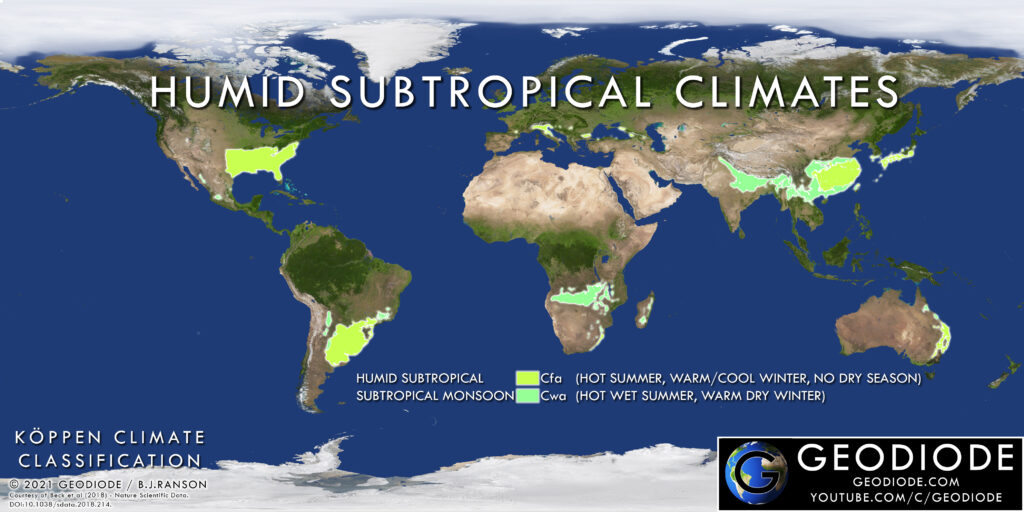
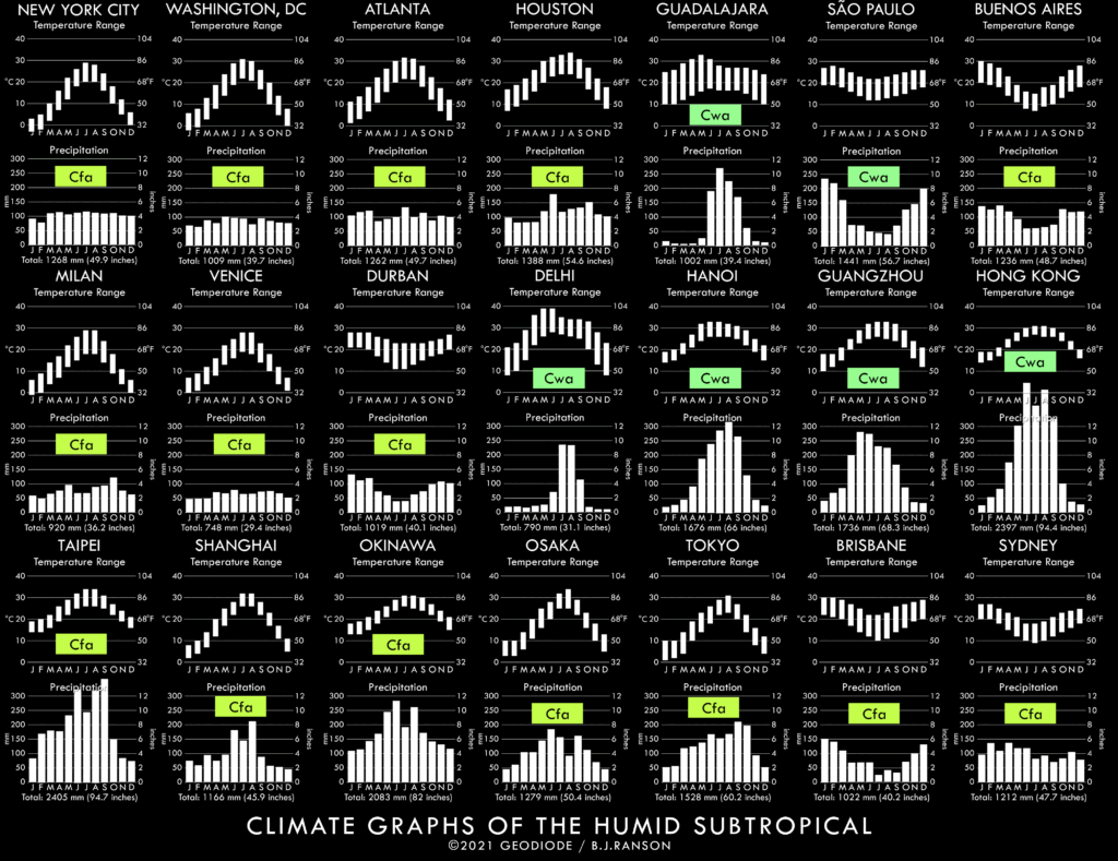
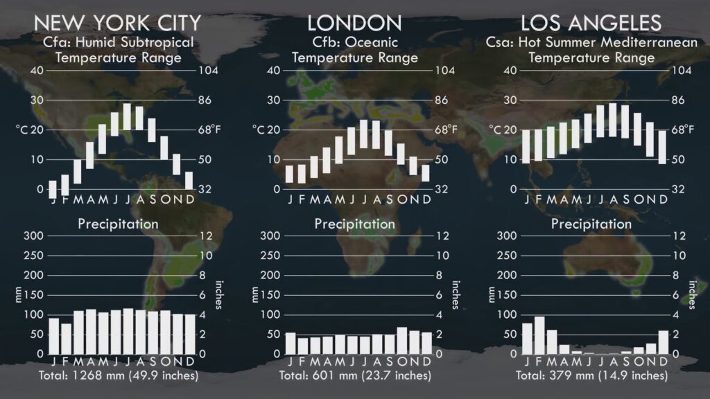
Hot summers, cool winters, and plenty of rain. You could live in a place like this, right? Well millions would agree with you. Because out of all the climate zones on earth, this is the one with the largest number of highly developed world cities.
It’s the only climate zone on every inhabited continent on Earth.
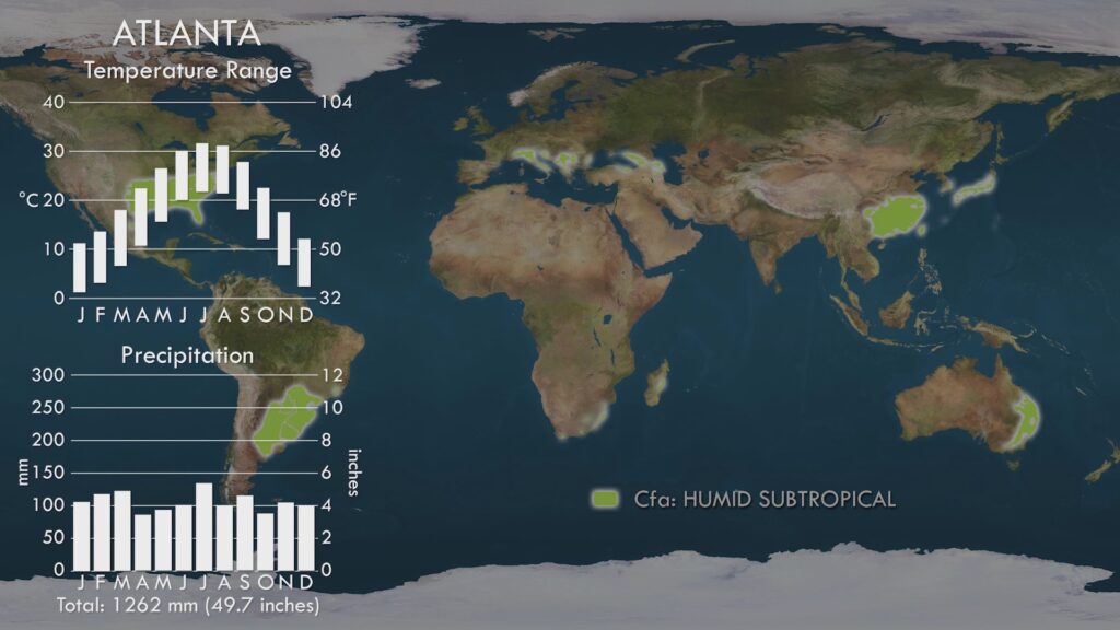
And you’ve probably never heard or thought of it until now. It has been dubbed the “China” type, the Natal type, the Southern United States type, or the Warm Temperate Eastern Margin. But in this series we’ll call it the Humid Subtropical.
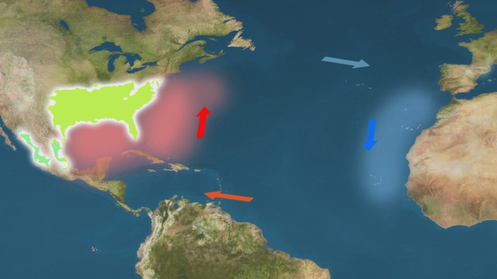
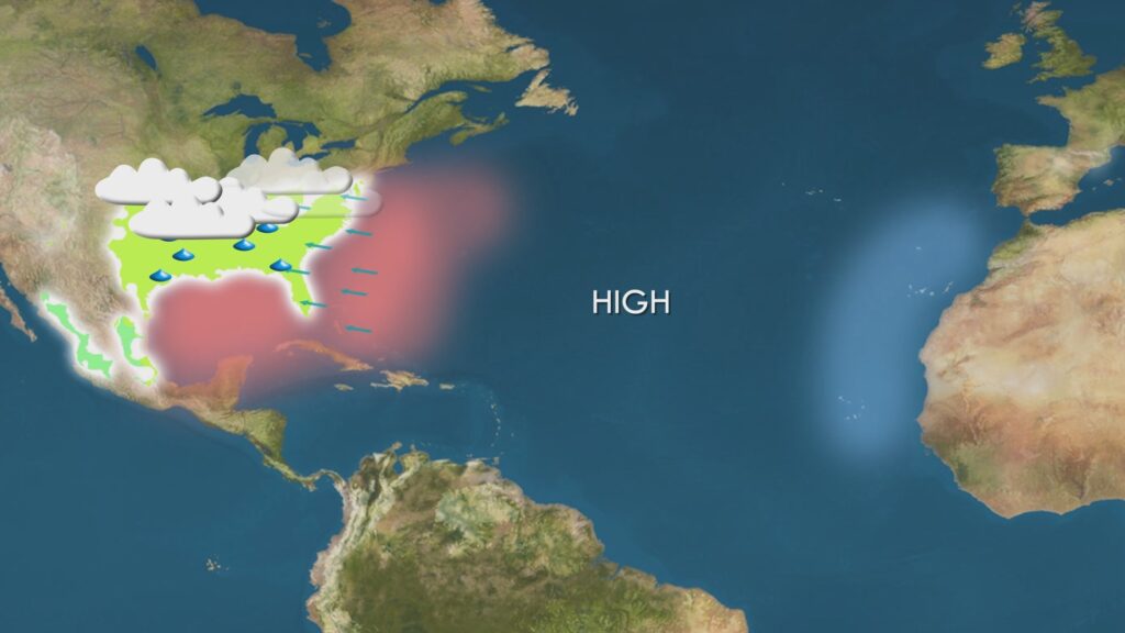
Description and Dynamics In our journey from the equator toward the poles in this series, it is now time to review the Temperate band, where we find most of the developed world. The climate zone in this band nearest the equator lies on the eastern boundaries of all the major continents between about 20 and 40 degrees latitude, and is called by most climatologists the Humid Subtropical.
What defines this climate is the generous presence of rain and a hot and humid summer where temperatures approach that of the tropics. But to distinguish it from such tropical zones, it has a cool winter where temperatures typically drop to between zero and ten degrees celsius. This seasonal variation is due to the increased latitude compared to the tropics. In summer the sun is close to overhead at noon, whereas in winter, it is much closer to the horizon, and so sunlight strikes the earth at an angle, spreading its heat over a wider area and diluting its power.
The angle of the sun to the land in Humid Subtropical summer is high, producing much surface heating
The angle of the sun to the land in Humid Subtropical winter is low, producing little surface heating
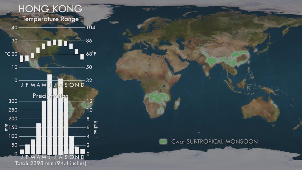
There are two subdivisions of this climate within the Koppen Climate Classification both of which share the seasonal variation in temperature just described, and differing only by rainfall pattern. The first, and most geographically widespread is Cfa, which experiences rain all year round. The second, Cwa, has rain mostly or only during the summer, and because of this similarity to the Tropical Monsoon, this is known as the Subtropical Monsoon, owing to its cooler winter temperatures when compared to its Tropical cousin.
The Humid Subtropical Cfa variant has year-round rain
The Subtropical Monsoon Cwa variant has rain only or mostly during the summer
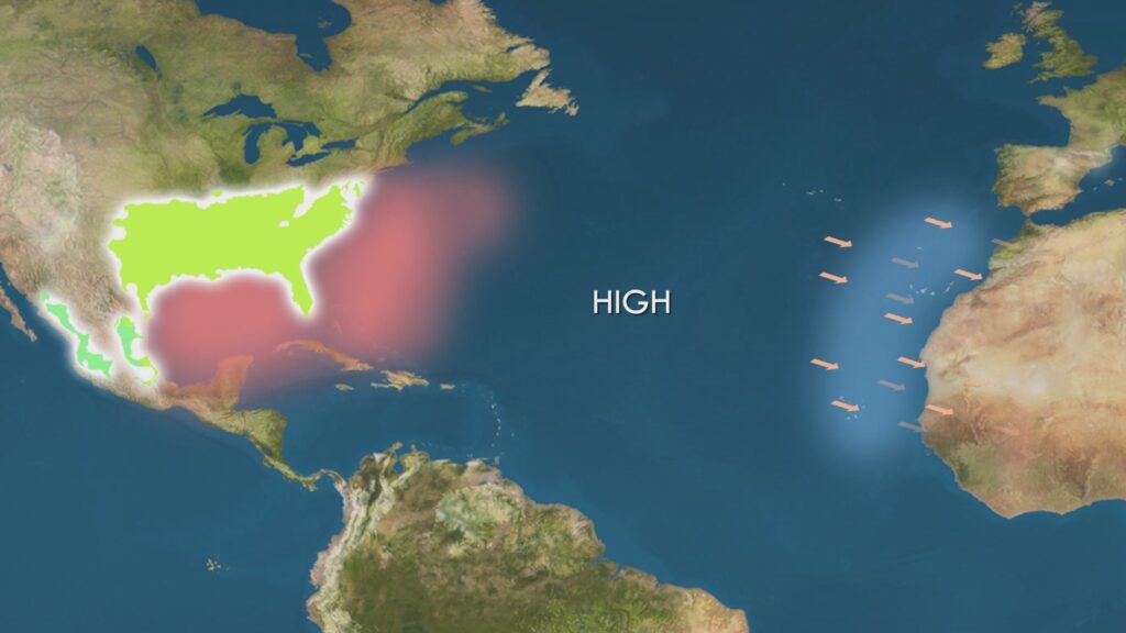
Now those of you paying attention in the last chapter on Hot Deserts may be saying ‘Wait a minute, that band just above the tropics should be desert, due to the descending columns of air originating from the tropical uplift!’… or something similar. So why, on the eastern edges of the continents at these latitudes do we get a wet climate instead of desert? Well, as usual in weather and climate, the full explanation is complex, but a simpler answer is that the oceans on the eastern fringes of the continents have warm water compared to the western fringes that have cold water, due to ocean current circulation. Warm ocean means lots of moist air above it, and this is pushed onto the land by the high pressure ridge that is concentrated to the east of each continent. When the warm moist air goes over land, it releases its moisture as rain. By contrast, the deserts at the same latitudes have air moving over cold water onto land, which at best produces fog, or no wind at all due to high pressure directly above them.
Current circulation always produces warm water on the western fringe of an ocean at the mid-latitudes
Warm moist air blows onto the continental eastern margin by high pressure, producing rain
By contrast, cold water in the eastern ocean margins blow dry air onto continental western margins producing no rain and deserts
Where in the world is there a Humid Subtropical climate?
Global Distribution of Humid Subtropical and Subtropical Monsoon Climate Zones
So where in the world do we find the Humid Subtropical climate? Well, the short answer is, on every continent excluding Antarctica, and it’s the only climate type to claim such an accolade.
Starting as we do in the Western Hemisphere, and moving eastward, we first encounter this climate in the south-eastern United States, where it covers almost a quarter of the entire country. From Missouri down to Texas in the west, across all the “southern states” out to the eastern seaboard, where it extends north all the way to New York City in the north and to all but the southern coast of Florida in the south. Further south on this continent, in Mexico, there are two bands of the monsoonal variant lying on each side of the central highlands.
In South America, we find another large stretch of the middle eastern part of this continent dominated by the Humid Subtropical. From south-eastern Brazil, including its largest city Sao Paolo, this region stretches out to encompass most of Paraguay, all of Uruguay, and the most populated regions of north eastern Argentina, including its capital Buenos Aires.
With this climate, we see our first entry into the continent of Europe. Specifically, in the northern and eastern parts of Italy, sheltered around the Alps to the north and the Apennine mountains to the south, we have humid summers and cool winters instead of the Mediterranean climate that otherwise dominates the larger region – more on that one in the next chapter. Pockets of this climate type occur further east in the Balkans, along with some of the coasts of the Black Sea.
In Africa, we find a band across the southern part of the continent under the influence of the Cwa monsoon variant of this climate, while in the extreme south east, in the Kwazulu- Natal region of South Africa, we get the all year round rain of the Cfa type.
In Asia, the Cwa monsoonal variant dominates a large stretch of northern India, including the capital of Delhi and most of the heavily populated Ganges river system. This band of the subtropical monsoon extends eastward into northern Vietnam and southern and mid China including the hugely populated Pearl River Delta, with cities such as Guangzhou, Shenzhen, Macau and Hong Kong.
The Cfa year-round rain variant in Asia occurs over a wider area in the main part of central and eastern China, including a host large cities such as the megacity of Shanghai. Moving off the coast of that continent, we have the whole of Taiwan, and the southern and eastern parts of Japan that form the major population centres of that nation, including the world’s largest urban area of Tokyo, that nation’s capital.
The last continent which has the Humid Subtropical climate is Australia, specifically the central eastern coast, including the cities of Brisbane, and that nation’s largest city – Sydney.
Despite its dispersal across all continents of the globe, the Humid Subtropical climate is proven as a particular and consistent type by comparing temperature and rainfall graphs across each of these areas.
Landscapes and Vegetation
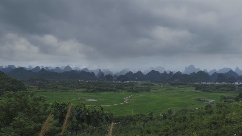
Countryside near Yangshou, South China
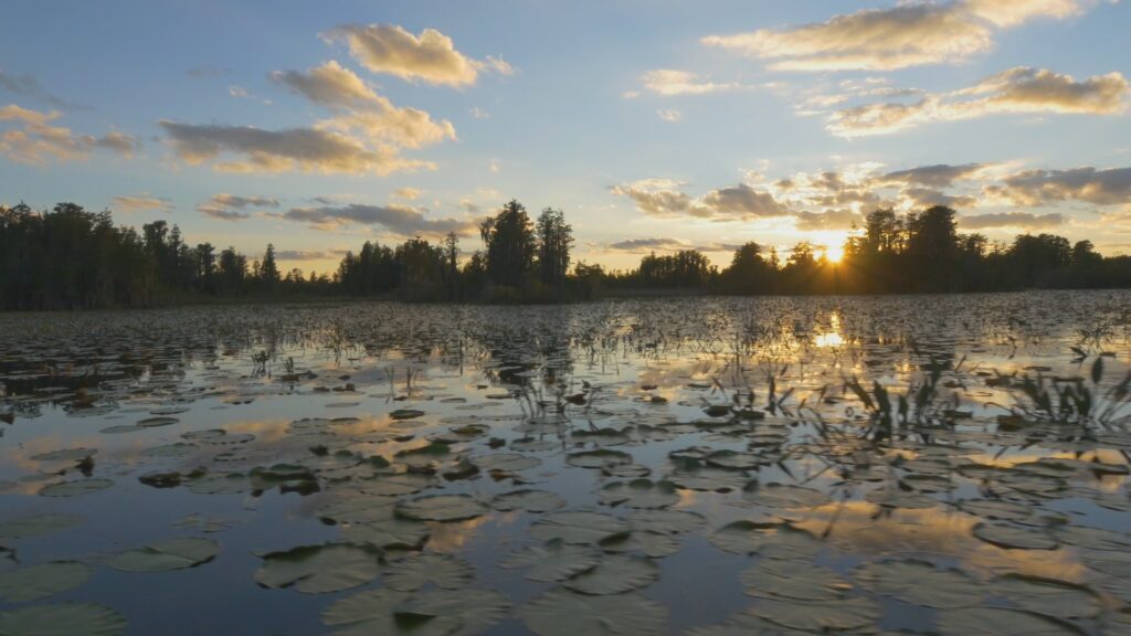
Wetlands in Georgia, USA
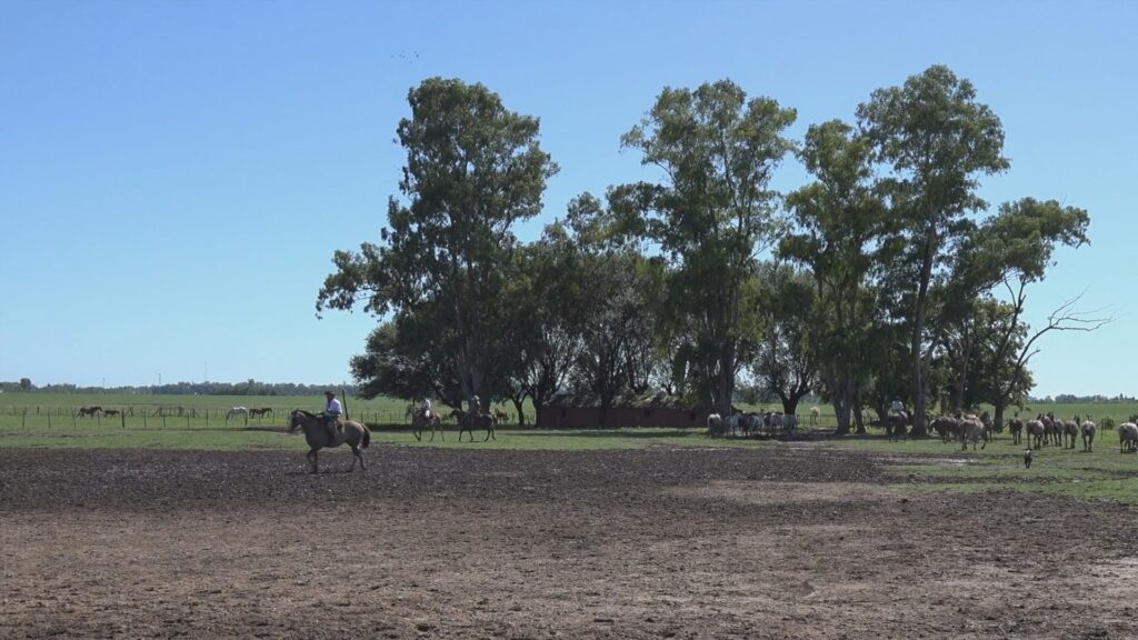
Gaucho ranchers in the Pampas of Argentina
So what kind of landscapes and vegetation do we find in the Humid Subtropical climate?
Low lying plains are the most common type of topography in this climate zone, and in their natural state, such plains would be covered by either mixed woodland or grassland. Being a temperate climate, this is the first that we see with four seasons, easily defined by the deciduous trees that mark this zone, whether in their natural habitat or included within the cities here – blossom in spring, green leaves in summer, the yellow and red falling leaves of autumn and bare in winter.
Because this moderate climate favours a diverse array of crops, however, most of it has given way to agriculture – rice, nuts, wheat, ranching, cotton, tobacco, and livestock ranching, depending upon the region.
Population and Cities
Notable cities with Humid Subtropical and Subtropical Monsoon Climates
With its relatively mild temperatures and plentiful rain supporting so much agriculture, high populations can be supported, especially the rice-supporting regions in China and India, meaning this climate zone is home to more people than any other. And being in one of the cities of the Humid Subtropical, under more tolerable conditions compared to the tropics, allows for large and sophisticated cities to develop on every continent – again more than any other climate type. The adjacent graphs provide just a sample of these.
Coursework Questions
Why does the Humid Subtropical climate experience high summer but low winter temperatures?
Why does the eastern margin of each continent experience rain at the subtropical latitudes, but the western margin does not?
What are the Koppen codes for Humid Subtropical climates? How do they differ from each other?
Why does this climate support such large populations?
List out some countries, regions and cities that experience Subtropical Highland climates.
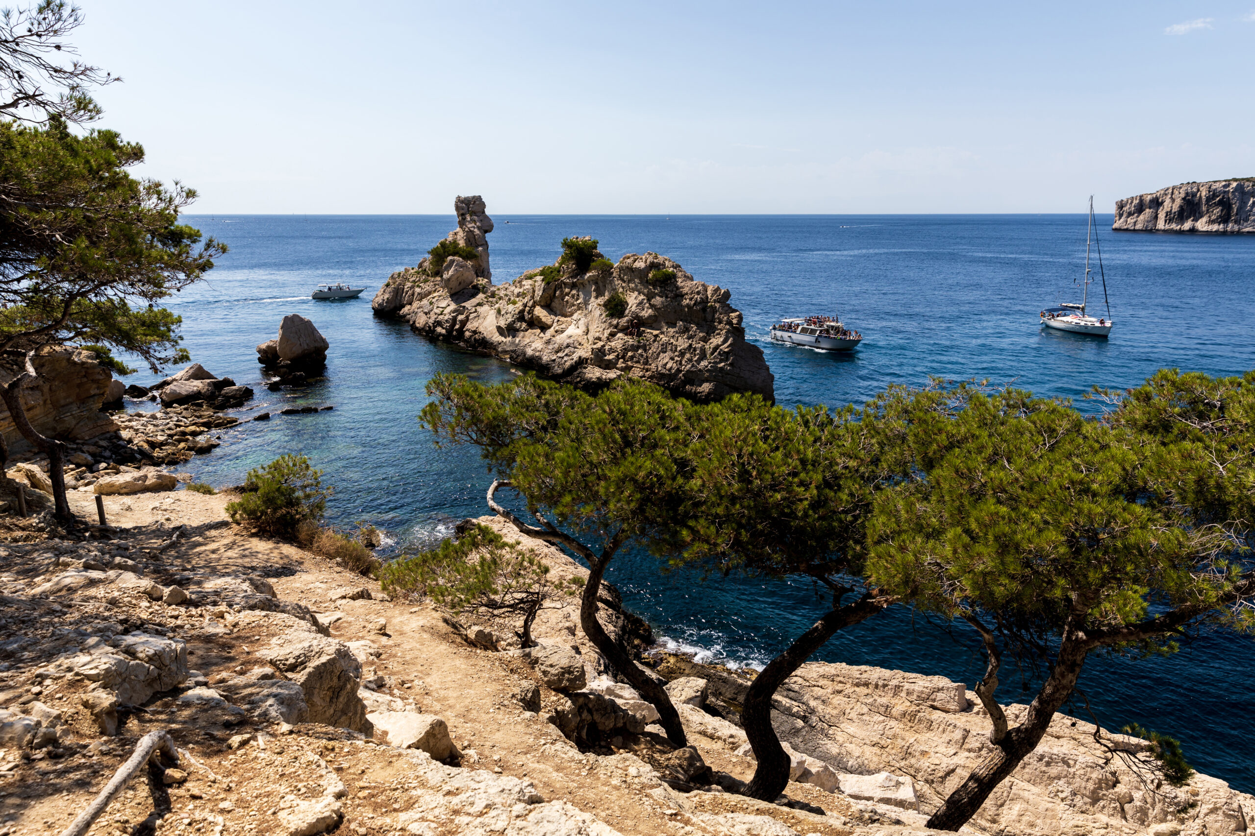
The world’s most famous sea. Endless coastlines and beaches. Histories and culture as rich as any on earth. Blessed with one of our planet’s finest climates – it’s the only one with a dry summer and wet winter.
But you’d be mistaken in thinking that this sea was the only place where such a climate existed. Copied across four other continents, this much-desired climate is home to a very famous state, and three very different countries far into the southern hemisphere. But in all places, this climate just has one name, the ancient home of the summer sun – the Mediterranean.
Description and Dynamics
As we continue our journey in this series from equator to poles, it’s now time to consider the second of the three climates occupying the temperate areas of the mid-latitudes, the Mediterranean Climate.
This climate zone has a similar temperature range to the Humid Subtropical climate that we covered in our last chapter – between 20 and 35 degrees in summer, and 5 to 20 degrees in winter. But the most immediate and striking aspect of this climate is in its rainfall pattern. Most world climates have their rainfall peak in the hottest months of the year, while others have year-round rain. But only one reverses the most common pattern – only the Mediterranean climate has a dry summer and wet winter.
To explain this unusual pattern, we have to consider both our earlier chapters on the Tropical Monsoons, as well as the Hot Deserts. You might want to review these earlier chapters to really get what’s about to follow.
Due to the 23 degree tilt of the earth, the convergence of trade winds in the tropics called the Doldrums shifts north and south throughout the year. The band that lies on the poleward side of this band is usually dry, due to extensive high pressures brought on by the downward component of the Hadley Cell of tropical air movement. In summer, this band of high pressure is pushed further out toward the poles, away from the Hot Deserts and into the temperate zone, causing a long drought in this season.
In winter, the Doldrums are either back at the equator or in the other hemisphere, so the high pressure area also follows it back that way. This allows more unstable air to return in the form of oceanic westerly winds, which, when blown onto westward facing coasts, bring rain. This explains why the Mediterranean climates zones lie on the western fringes of each continent.
The subtropical Hadley Cell is pushed poleward in summer, leading to descending air, high pressure and drought over the Mediterranean
In winter, the Hadley Cell moves back to the equator, allowing low pressure areas and rain carried by westerly winds into the Mediterranean
The presence of water in the Mediterranean allows extension of moisture bearing westerlies to extend rain all the way to Lebanon and Israel
The presence of the Mediterranean Sea at just the right latitude, allows these westerlies to gather continual moisture as they travel east, extending the winter rain all the way to the coasts of Lebanon and Israel at the far end of this sea. The consistency of this climate type is well illustrated by comparing city graphs from the west to the east of the Mediterranean.
Cities all across the Mediterranean show consistent winter rain and summer drought
We’ll talk more about the Westerlies in the next chapter on the Oceanic climate, since they are the dominant component of weather in those regions lying immediately poleward to the Mediterranean areas.
Because the Mediterranean summer is uniquely drought-filled, compared to all other climates except deserts, this peak season of heat is accompanied by low humidity – what Californians love to call “a dry heat”. As perspiration is more efficient in dry air, this heat is a good deal more comfortable than, say, the humid summers of Georgia or Florida at the same latitude.
There are two subdivisions of the Mediterranean climate within the Koppen Classification system both of which share the dry summers and wet winters just described, and differing only by temperature range. The first, and more common form is Csa, which experiences a hot summer of at least 22 degrees averaged across the night-day cycle. This is known as the Hot Summer Mediterranean. Where the average summer temperature is below 22 degrees, this is known as the Warm Summer Mediterranean and has the Koppen code Csb.
Global distribution of Mediterranean climate zones
Where in the world do we find Mediterranean climate zones?
So where in the world do we find the Mediterranean climate? Well, the short answer is, on every inhabited continent except Asia, which lacks the necessary west coast.
We begin in Europe, and the sea from which this climate gains its name. To the west of the Mediterranean, out in the Atlantic, the Azores experience warm dry summers and wet winters. Moving east onto the Iberian Peninsula we find the cooler Csb variant of warm summers and very wet winters in the north of Portugal and North-Western Spain. Further south, we move into the hot summer Csa variant that Portugal’s capital of Lisbon experiences, along with most of Spain, and its capital Madrid. In the extensive interior of the Iberian Peninsula, however, some areas are so dry that they are classed as cool semi-desert – we’ll pick these up in a future chapter.
The wet winters that define the Mediterranean type extend deep into Morocco on the North African coast, and as we move east into the western Mediterranean basin, the entire Algerian coast and northern Tunisia also fall within this climate. All the islands in this area have this climate – the Balearics, Corsica, Sardinia, Sicily and Malta. The northern coast includes the luxurious Cote d’Azur of France and this coast extends east into Italy, the heart of Mediterranean, where the dry summer / wet winter pattern extends inland across all western and southern provinces, including the nation’s capital, the Eternal City, Rome.
Coast of Andalucia, Southern Spain. Koppen Csa (Hot Summer)
Island of Kefalonia, Western Greece. Koppen Csa (Hot Summer)
Coast of Oregon, USA. Koppen Csb (Warm Summer)
Continuing east across the Adriatic sea, much of the coast of Croatia and all of Albania are within this climate, along with all of Greece, including its legendary capital of Athens, and all of the Greek islands. Now firmly into the Eastern Mediterranean basin, we reach the long coastline of Turkey, where the wet winters and dry summers extend well inland, encompassing that country’s largest city, the ancient metropolis of Istanbul. Finally, at the eastern end of the Mediterranean, the coast turns south into Syria, Lebanon and Israel, including the cities of Damascus, Beirut and Jerusalem.
In North America, the entire west coast of the United States comes under the influence of this climate, from the coasts of Washington and Oregon in the north, with their very wet winters – this is the largest area on Earth where we experience the warm summer Csb variant of this climate. As we head south into California, the winters become shorter and drier, the summers longer and hotter, and we have the classic Csa Koppen variant. An exception is San Francisco, which stays much cooler than the surrounding area due to the proximity to cold ocean currents which often shroud the city in fog. As we reach Southern California, and the massive conurbation of Greater Los Angeles, fog and coastal cloud is less common, and summers hotter, especially as one moves further inland away from the cool ocean. The last stop for this climate zone are the cities of San Diego and Tijuana lying on each side of the US/Mexico border, before the climate gives way to the hot desert of Baja.
Landscape of Central Chile. Koppen Csb (Warm Summer)
Winery near Cape Town, South Africa. Koppen Csb (Warm Summer)
Esperance, Western Australia. Koppen Csb (Warm Summer). Image courtesy of S Lui
Moving now into the Southern Hemisphere and South America, we encounter this climate in the cooler Csb form, worlds away from its namesake, along the mid-coast of that longest of countries, Chile. It’s in this zone where most of that country’s population lies, including the main port of Valparaiso, and the capital Santiago.
In Africa, south of the Namib Desert, we find the extreme south-west of South Africa caught by the wet winter westerlies that typifies the Csa form of the Mediterranean climate, most notably around the city of Cape Town, famous for its dramatic backdrop of Table Mountain.
The last continent to experience this climate zone is Australia, where it brushes two parts of the south and west facing coasts, firstly around Perth, the most isolated city in the world, in the far west, and again, around the mid-southern city of Adelaide.
Notable cities with Mediterranean Climates
Despite its dispersal across so many continents of the globe, the Mediterranean climate is proven as a particular and consistent type by comparing temperature and rainfall graphs across each of these areas. Note the 6-month switch between the northern and southern hemisphere in terms of temperature and rainfall, demonstrating the reversal of seasons on each side of the globe.
Landscapes and Vegetation
So what kind of landscapes and vegetation do we find in the Mediterranean climate? Throughout the world, plants have adapted to survive the drought of summer, which, occurring at the hottest time of the year, places a particular challenge due to very high evapotranspiration rates. The Csa Hot Summer areas all have a similar and distinctive look – one similar to a semi-arid desert, where shrubs form the dominant plant life separated by patches of hardy grasses, bare earth and rock. A distinctive hallmark of Mediterranean plants is the greyish-green appearance, a product of the hard, waxy layer of leaves designed to hold in moisture during the hot summer drought.
In the cooler and wetter Csb areas, shrubland gives way to forest, and it is in such areas within California that we find the tallest trees in the world – the sequoias or redwoods. In Australia, the Eucalyptus tree has adapted particularly well to summer droughts and is found throughout that continent. So successful is this family of trees in this climate that it has been exported to other Mediterranean climate zones where it has thrived.
Agriculture and… Culture!
In terms of agriculture, the Mediterranean areas have two world famous crops. Grapes and olives. The drinking of wine, from the fermented juice of grapes has gone on in the Mediterranean and Near-East since ancient times, and in the last two centuries has been exported to all other Mediterranean climate areas, as wine drinkers will know, from seeing bottles originating from California, Chile, South Africa and Australia. The pressing of olives to produce olive oil has also gone on since ancient times, and to this day the oil is valued across the world for its health properties as well as its distinctive flavour. Many other crops are grown in these regions, of course, particularly wheat and citrus fruits, but these are more common in other climates than grapes and olives.
The Mediterranean climate type is an example where climate has directly had an impact on humanity outside the world of agriculture. In one case, the Mediterranean itself is the world’s most popular tourist area, seeing a third of a billion visitors per year. With its endless coastlines and historical and cultural attractions, tourists come here in the summer knowing that they can enjoy guaranteed sunshine and warm weather. A second example is less obvious, and that is the world movie capital of Hollywood, California. In the early days of movie production, when film needed bright light, production companies located to Los Angeles where for most of the year they could be guaranteed bright sunshine and no rain that would otherwise interrupt the shooting of movies.
Coursework Questions
In what important way is the Mediterranean climate unique among world climates?
How does the movement of the Hadley Cell between summer and winter lead to the unusual rainfall patterns seen in Mediterranean climate zones?
What are the Koppen codes for these climates? How do they differ from each other?
What types of natural landscapes do we find in the Mediterranean climate zones?
Describe how the Mediterranean climate has a direct influence on humanity outside of agriculture.
List out some countries and cities that experience hot desert climates.
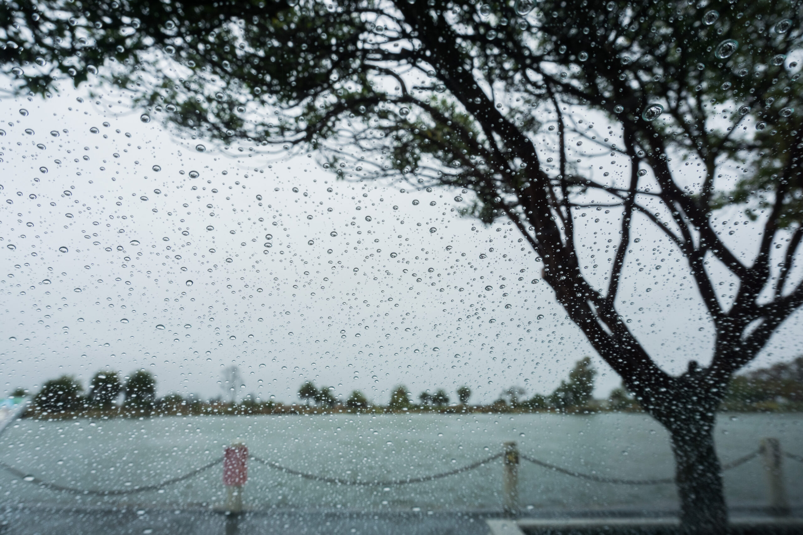
Cool oceans. Westerly winds. Storm-driven rains. Half-way between equator and pole, the lands on the westerly fringes of the continents are dominated by their neighbouring seas.
Mild winters. Mild summers. If you excuse the constant ocean storms, cloudy skies and rain, then these are not lands of extremes. Having some of the most dramatic coastlines on earth, these lands carry also idyllic green countryside that has been the inspiration of poets and authors down the ages.
These are the lands that birthed not one, but three global empires. Defined by the cool ocean winds, this is the Marine West Coast, the lands of the Oceanic Climate.
Description and Dynamics
As we continue our journey in this series from equator to poles, it’s now time to look at the last, and most northerly of the three climates in the temperate band – the Oceanic Climate.
The Oceanic climate borrows elements from the other two temperate climate types
In some ways, this climate is a combination of the Humid Subtropical and Mediterranean climates that it shares the temperate band with. It has the year round rain and occasional humid summer heat of the Humid Subtropical, but with winters similar to the cool Mediterranean, with whom it shares its westerly winds. Like the Mediterranean climate, it also has a very mild temperature range between summer and winter, but is a good 10 degrees cooler than its sunnier and hotter counterparts in summer due to its more polar latitude. Averaged across the day-night cycle the temperature is above freezing (32°F) in winter, but below 22 degrees Celsius (72°F) in summer.
This does not prevent deep night frosts in winter cold snaps, or peak day temperatures from reaching 30° or more during a summer heat wave. But these events occur infrequently in this land of mild oceanic influence.
In comparison to its southerly neighbour, the Mediterranean, the people that live in these lands love to complain about the most distinctive feature of this climate when compared to others, the lack of sun. While other lands, especially in the tropics are wetter, the Oceanic lands are dogged by frequent cloud cover, with at least half the days throughout the year seeing cloudy or rainy days.
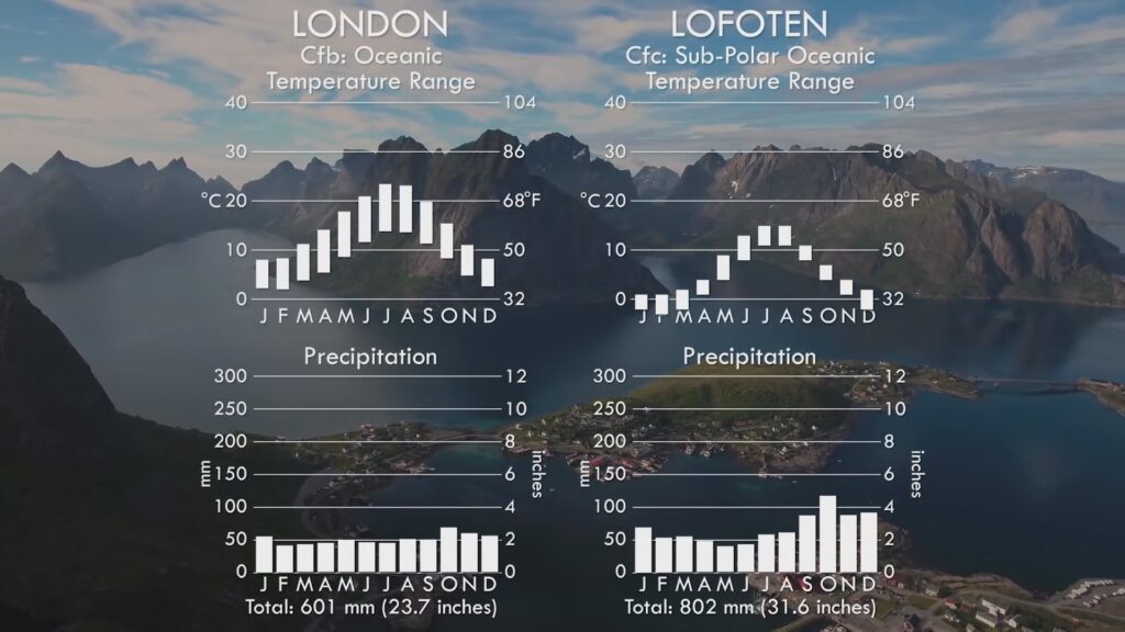
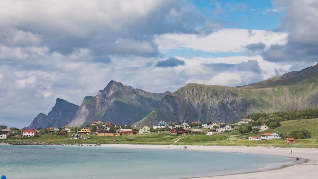
The Marine West Coast yet has a more favourable superlative, in that it exhibits much milder winters compared to all other regions at the same latitude. While it is 20 below freezing in Siberia, it is 5 degrees above in London. This “anomaly” is at its most extreme in the north of Norway, where in Lofoten, it is above the Arctic Circle, and yet stays above freezing in winter, due to the presence of warm currents of the Gulf Stream and North Atlantic Drift bringing warm waters from the tropics.
This climate is dominated by Westerly winds blowing in from the adjoining oceans. Most pronounced in autumn and winter, these winds bring in storm after storm, battering the coasts of these areas with heavy rain and gales, while more inland areas, spared the worst, nonetheless experience wind and rain on a regular basis. Spring and especially summer see less of the westerly wind conditions, but weather can remain unpredictable even during these seasons, as any Brit or Kiwi will tell you when anxiously planning a weekend barbeque.
The Polar Jet Stream that drives westerly winds at the mid-latitudes
Low and High pressure systems spin in opposite directions, strengthening the jet stream
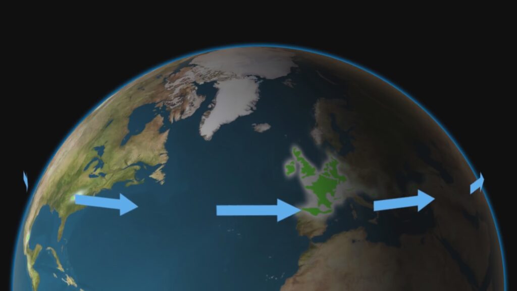
Winter sees both Oceanic and Mediterranean climates experiencing wet westerly winds
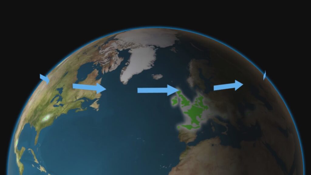
In summer, only the Oceanic climate is affected by the jet stream, with the Mediterranean unaffected and remaining dry
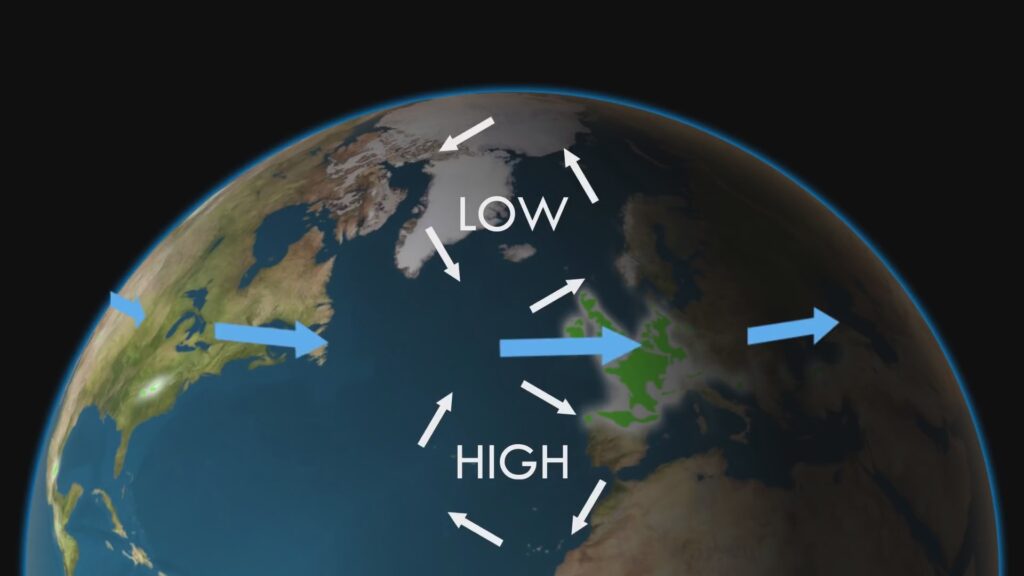
At the heart of these westerlies is a meteorological phenomenon known as the Polar Jet Stream. This is a narrow band of high altitude winds that frequently exceed 100mph, and circles the north and south pole at a latitude of between 50 and 60 degrees, travelling from west to east. It occurs at these latitudes, since it is in this region that winds from the tropics and poles converge. Due to a complex mechanism known as the Coriolis effect, air moving between high and low pressure is forced to spin. In the case of the more equatorial high pressures, the poleward sides of these travel west, in the same direction as the equatorial sides of more polar low pressure areas, providing a constant momentum to this jet of air. In winter, the jet stream travels toward the equator with the retreating high pressures, impacting both the Oceanic and Mediterranean west coasts. In summer it retreats back toward the pole, leaving alone the Mediterranean climates but still brushing the Oceanic zones. This explains why the Mediterranean zones only get rain in winter, while Oceanics get rain all year round.
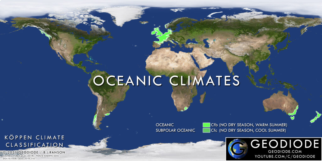
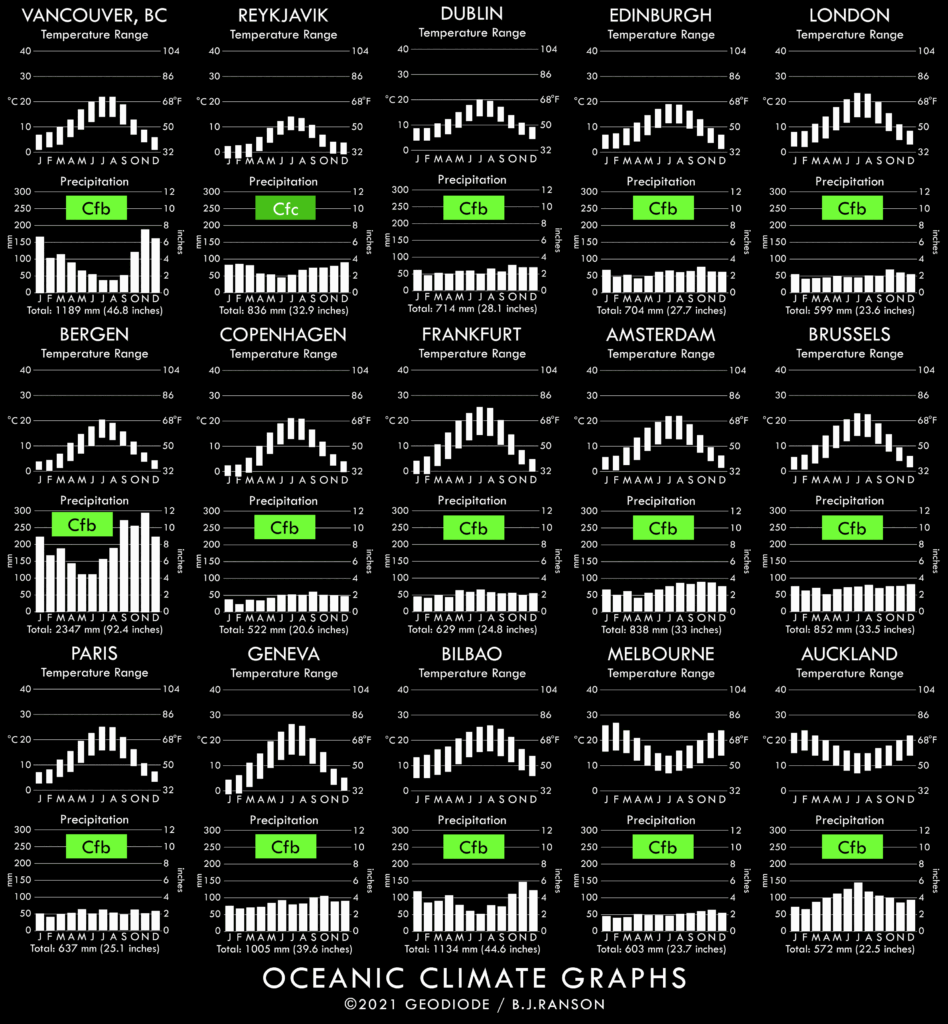
There are two subdivisions of the Oceanic climate, separated only by summer temperatures. The most significant in terms of land area and population is designated with the Koppen climate code Cfb, which sees maximum summer day temperatures above 17°C (63°F). This is known as the Marine West Coast, or Marine Mild Winter, or simply the standard Oceanic climate. The other, Cfc, known as the Subpolar Oceanic climate does not see summer maxima above 17°C. Since both have similar winter temperatures, the Cfc variant therefore has a significantly narrower variation in seasonal temperatures.
The Oceanic climate is, like the Humid Subtropical, a true four seasons climate, with the usual pattern of blossom in spring, green leaves in the growth season of summer, yellow and falling leaves in the autumn and bare branches in winter. Snowfalls usually occur at least once per winter, but usually melts within a few days. Cold snaps of below freezing conditions lasting a week or more are rare but not unknown.
Classic Oceanic (Cfb) has warmer year round temperatures than Subpolar Oceanic (Cfc)
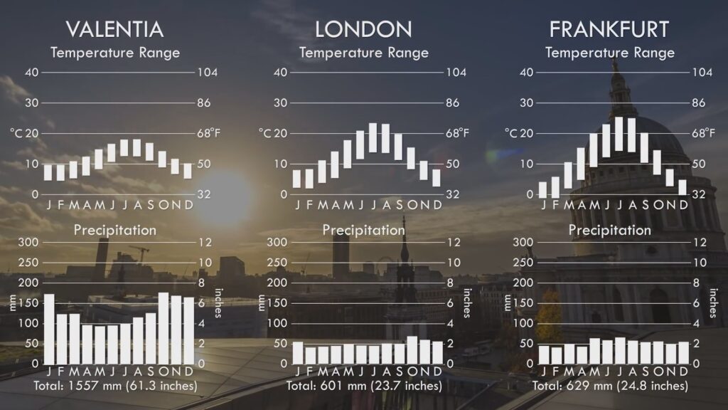
Valentia in the west of Ireland has much wetter but milder conditions, while Frankfurt has more continental influences than London in the middle of this climate zone
The influence of the ocean can be seen in this sample of graphs stretching across Northwest Europe, which is the most significant part of the world under the Cfb Oceanic climate in terms of population. The west coast of Ireland has the narrowest summer/winter temperature range. while moving east into England, and then into Germany, the temperature range increases as we head to the border of the Continental climate zone further east.
Where in the world do we find the Oceanic climate?
So, where in the world do we find the Oceanic climate areas? Well, they mostly lie on the western coasts of continents where they extend beyond 45 degrees of latitude. Starting in North America, the extreme north-west of American State of Washington, the west coast of Canadian British Columbia and the southern half of the Alaskan panhandle come under its influence. Due to the closeness of the Rocky Mountains, this influence does not extend far inland, but nonetheless, covers the key regional city of Vancouver, which experiences the mildest winter temperatures in Canada.
Countryside in Victoria, Australia
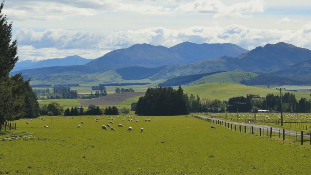
Countryside in New Zealand
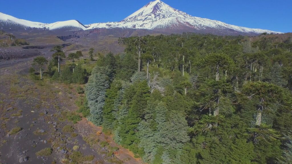
Southern Chile – Araucaria Trees against one of the many prominent volcanoes here
A mirror image of this pattern occurs in South America, where the southern third of Chile is covered by first Cfb and then Cfc variants of this climate as one heads toward the southern tip of the continent and Antarctica. Again, an extensive mountain range, the Andes, is immediately adjacent to the coast, thus limiting the influence within the narrow margin of this longest of countries.
Global distribution of Oceanic climate zones
Skipping all the way, now, across to Australia, and we find the south-eastern margin of this island continent containing among the warmest of the Oceanic climates with all of Tasmania, most of Victoria and the southern coastal fringe of New South Wales under its influence, including the state capitals of Melbourne and Hobart. At first this might seem a contradiction to the “westerly coasts” model of this climate, but in actual fact, this is the only part of Australia that extends far enough south to have year-round westerly winds.
Travelling further east still, and we reach the most isolated country in the developed world and the two islands of New Zealand. Both islands are dominated by Westerlies year round since they are firmly in the latitude of the “Roaring Forties” and so all but the most mountainous parts of this country lie firmly within the Oceanic climate zone. Like all such zones, temperatures are mild in winter, but summer temperatures are significantly warmer in the north compared to the south.
Lastly, we come to Europe, where this climate zone most strongly leaves its mark, both in terms of land area, and population. In the far north and west, we have the island of Iceland, land of the midnight sun, so far north is it that it touches the arctic circle. The lower lying western parts of this island, including the capital Reykjavik are under the Polar Cfc variant of the Oceanic climate, experiencing cool summers, but also mild winters due to being firmly within the warm Gulf Stream ocean current. At a similar latitude, we have the long and broken coastline of Norway, where in the north the Cfc Polar Oceanic variant keeps winters mild and summers cool, but as we travel further south along this coast, this turns to the standard Cfb Oceanic variant.
Hopping across the North Sea, and we arrive in the British Isles, where both islands of Great Britain and Ireland are firmly within the Cfb Oceanic zone. The Western coasts of Ireland and Scotland have the most rain, and mildest temperature ranges, being directly washed by the warm Gulf stream ocean current. Further east, on the leeward side of the mountain ranges of Wales and Scotland and throughout England, winters in England are cooler and summers warmer. It could be argued that the British are masters of weather complaining, being forever lashed by Atlantic storms, and yet also, when a particularly cold winter snap or summer heat wave strikes, we also complain, since such events lie outside the normal mild range that we in these islands are so used to. I, of course, am speaking from native’s perspective.
Mixed forest in Eastern France
Countryside in Western Ireland
Lofoten in Northern Norway – one of the few spots with the Subpolar Oceanic (Cfc) climate
Heading south across the English channel and Bay of Biscay and we arrive on the main continent of Europe, where the north coast of Spain is visited by Atlantic storms year round. Heading north and east, and we find that most of France is under the Oceanic influence, and like Victoria in Australia, has some of the warmest summers that this climate has to offer. As we continue to move north and east along the North European plain, we find few obstructions in the form of mountains to block westerly winds and so this climate extends east into north and west Switzerland, then north into the low countries of Belgium and the Netherlands, and further east into Germany, where it covers the bulk of that country, from Bavaria in the south to North Sea coasts in the north. Parts of Denmark are also under the Oceanic influence, but, like Eastern Germany, this country lies on the border of the continental climate of more seasonal extremes, which we’ll take up in that future chapter.
Despite being spread across so many continents, the mild Oceanic climate is shown as a particular and consistent type by comparing temperature and rainfall graphs across each of these areas.
Notable cities with Oceanic Climates
Notable Cities
The Oceanic climate is host to many well known cities, since it covers the large population centres of North-West Europe. However, lets not forget the other parts of the world where this climate is mirrored, including cities in Canada, Australia and New Zealand. The adjacent chart shows the most notable of these.
Landscapes and Vegetation
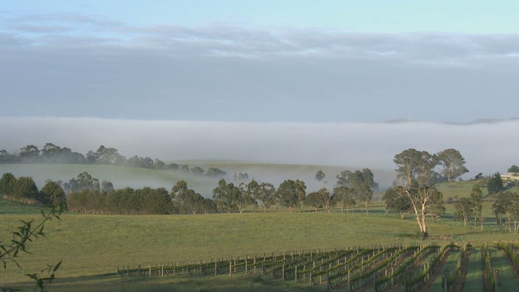
The Oceanic climate has some of the most enviable landscapes in the world. An upside to the year round rain, and not subject to intense, burning sun of less temperate climes, the lands of the Oceanic climate are green in a way that no others are. Broken, mountainous coasts with deep valleys, known as Fjordlands are a hallmark of this climate. From British Columbia, to Southern Chile, South Island New Zealand, and the country that gave its name to such landscapes, Norway, no other climate zone possesses these particular natural gems in such quantity. At the other extreme, we have the plains and rolling country of South Eastern Australia and Europe, that under human hands over centuries have produced the archetypal form of what we would call “countryside”.
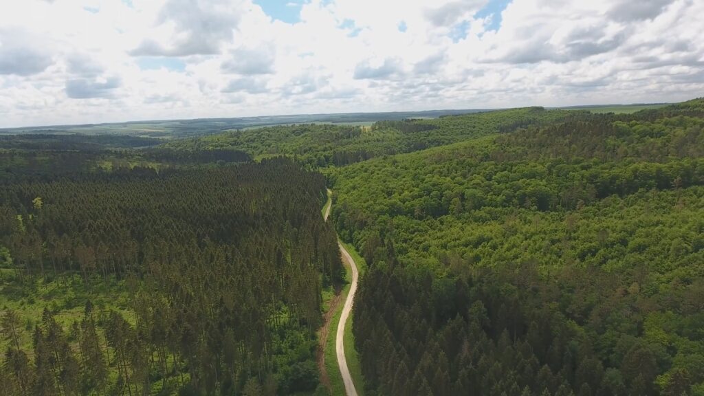
In its natural state the Oceanic climate is covered in thick woodland, either of a deciduous or coniferous nature, depending on the region. In some small surviving enclaves we can find areas of temperate rainforest, where so much rain falls that these lush woodlands are thick with trees, moss and ferns, producing a very rich green bioscape.
Agriculture
Most of the natural forest in Europe has given way to farmland, where a vast array of crops are grown, from apples and strawberries to wheat and grapes, including world famous French wine growing regions such as Champagne, to a host of different vegetables and even flowers. The Netherlands, at the heart of the Oceanic climate zone has some of the richest farmland in the world and is one of the few countries which exports more food than it eats, so much so that it has been called the Market Garden of the World. Some of the finest cattle breeds have emerged in this area, including the Frisians or Holsteins of Holland and North Germany, the world’s most productive dairy breed, plus the Aberdeen Angus of Scotland, considered the world’s finest beef cattle by many. Northwest Europe, with its rich soil suited to the cultivation of barley, also produces the widest array of beers in the world including most of the world’s famous brands, with Ireland, England, France, Belgium, Holland, Germany and Denmark all contributing significantly.
The region’s finest breeds and seeds have been exported all around the world, and there is perhaps no other area more influential in terms of agricultural diversity in the developed world. An example where this has occurred is in the identical climate zone covering New Zealand. Here, the Kiwis have exploited this mirror image of the European climate, where the seasons are reversed, allowing them to sell to Europe kiwi fruit, apples and lamb during the Northern hemisphere’s off-seasons of autumn and winter.
Coursework Questions
What is the dominant airstream in the Oceanic climate? How is it generated and what are its effects?
Why does the Oceanic climate experience year-round rain, but the adjacent Mediterrean climate sees only rain in winter?
How do lands in the Oceanic climate compare in temperatures to other places at the same latitude? Why is this?
What are the Koppen codes for Oceanic climates? How do they differ from each other?
Describe both natural and human-influenced landscapes in this climate zone.
How important is agriculture in this climate and describe its influence on the rest of the world?
List out some countries, regions and cities that experience Oceanic climates.
Majestic landscapes. Endless plains. Where a lack of rain combines with cold winters. On the wrong side of mountains, or thousands of miles from the ocean. One such place is the driest on our planet.
The unlikely centre of the largest land empire in history. And the only world climate to spawn a popular genre of fiction. These are the cool deserts of Planet Earth.
Description and Dynamics
As we continue our journey in this series from equator to poles, we have reached as far north as we can go for the time being with the Oceanic climate. So it’s now time head into the interior of the continents at the mid-latitudes. And the first of the climates we will look at here are the cool deserts.
Like the hot deserts that we covered in Chapter 4, the cool deserts are defined by a lack of rain throughout the year. But the mechanisms that cause such drought are very different. Found at higher altitudes, deep with the northern continents hundreds or even thousands of miles from the moisture of the ocean, or on the leeward side of great mountain ranges, these causes are very different to the mass downward movement of tropical air that causes the hot deserts such as the Sahara, Kalahari or Mojave.
Continentality: Where an area is so far from the ocean, any winds reaching it have already lost their moisture
The first of these mechanisms is called “Continentality” – literally being in the middle of a large continent, so far from the ocean, that any wind that has penetrated thus far has been sapped of any moisture that it started with. The great deserts of Central Asia are a good example of this – these areas are factually the furthest from any ocean on the planet.
Another cause of cool deserts is what is known as “Rain Shadow”. Winds originating from the ocean almost always carry moisture, but if these winds hit mountains, the air is pushed upward and cooled, causing it to lose its moisture upon the windward slopes of these mountains, such that when the winds have passed over, there is nothing but dry air left, and so any land found on this leeward side receives little or no rain. Rain shadow is perfectly illustrated by taking a look at a satellite image of lower South America. The wet and dry regions can clearly be seen by the presence or absence of green. In the southern part of the continent, the prevailing winds are westerly, as we showed in the last chapter on Oceanic climates. So southern Chile, on the windward side of the Andes is wet, while Patagonia on the leeward side is dry. Travel further north, however, and the prevailing winds are the easterly trade winds of the tropics that we covered in Chapter 2. These winds are sapped of moisture as they travel over the high altiplano of Bolivia, such that they are bone dry by the time they reach the Atacama desert, the driest place on the planet outside of certain valleys in Antarctica.
Rain Shadow: Deserts are found on the leeward side of mountains as these slopes push any moist air depriving it of moisture as rain on the windward side
Rain shadow over the Southern Andes – prevaling westerlies lose moisture over Chile leading to the Patagonian desert
A final factor is where one would normally find a hot desert, but high altitude typically in the form of high plains or plateaux, results in cooler temperatures and frosty winters. This is the cause of much of the arid conditions in the Western United States.
Differences in altitude in nearby desert regions can determine either Hot or Cool Desert climate
The cool deserts differ in terms of recorded climate in one key way, and that is winter temperatures. Cool deserts can get as warm in summer as the hot deserts, but in winter, temperatures can plunge to minus 30 degrees or lower, whereas hot deserts rarely touch freezing point.
In the Koppen climate classification system, cool deserts are subdivided into two climates, depending upon how much rain falls. The truly dry cool deserts have the classification BWk – this is the classification of the Atacama and Karakum deserts, where very little vegetation grows, and where no major cities are located due to the harshness of the environment. Where more rain falls, the classification BSk is ascribed, which is referred to as cool semi-arid, or simply steppe, from the Russian word for short grass, since such grasses predominate in this climate in a wide band across central Asia.
Where in the world do we find Cool Desert Climates?
So, where in the world are the cool deserts? Starting in North America, we find that most of the inland western half of the United States is dominated by arid or semi-arid conditions. In the south, the arid conditions of Nevada, northern Arizona and New Mexico are extensions of the hot deserts of the Mojave and Chihuahua, where higher altitudes lead to freezing winters and a cool classification. Further north into the eastern parts of Oregon and Washington, and most of the states of Utah, Colorado, Wyoming and Montana, we have continentality and rain shadow both contributing to this huge area of dramatic landscapes and big skies that gave birth to the books and movies of the Western genre. On the eastern slopes of the Rockies, the plains are lower, but within the rain shadow of the Rocky Mountains. But with occasional moist rains bubbling up from the south, dry prairies rich in wheat farmlands are possible and dominate the landscape.
The Grand Canyon, Arizona, USA. The top is cool desert, due to altitude, but the Colorado River at the bottom, is hot desert
Valle de la Luna, Atacama Desert, Chile. Image courtesy of Thomas Noisel
The Taklamakan Desert of Central Asia, as seen from space. Image courtesy of NASA.
Northern fringes of the Gobi desert, Mongolia, where it blends into the Steppe. Image courtesy of Thomas Noisel.
Global Distribution of Cool Desert Climate Zones
Global Distribution of Cool Desert Climate Zones In South America, we find the famous Atacama, driest of all deserts, a product of the rain shadow of easterlies over the Andes, while further south, the desert switches sides with the winds moving to the west, and the result is the dry semi-desert of Patagonia.
Southern Africa and Australia also have bands of cool arid and semi-arid conditions that border on the hot deserts to their immediate north.
Much of Eastern and Central Spain is classified as cool semi-arid, due to a combination of moderately high altitude, and weak penetration of winterly westerlies into the interior of this wide peninsula at the Mediterranean latitude.
Climate graphs of some places with Cool Desert climates
Last we come to Asia, where the sheet enormity of this continent produces a band of arid landscapes so far from the ocean, comparing in size to the Sahara. On the western edge, we have the country of Iran which is dominated by cool desert, largely due to its higher altitude compared with the rest of the hot and dry Middle East. As we move north and east we continue the high altitude and dry mountains into Afghanistan, and north again we are into the flat Karakum desert of the Central Asian republics of Turkmenistan and Uzbekistan, also home to the Aral Sea, once one of the biggest freshwater lakes in the world, but now reduced to a salty remnant due to over-irrigation. Moving further north and we are into the large semi-arid steppe of Kazakhstan, which then blends into the richer grasslands of central Russia. We’ll take up these in the next chapter. Hopping over the Altai mountains, and we arrive in Western China, and the great sandy Taklamakan desert, a product of both continentality and rain shadow, with mountains on all sides leading to extremely arid dune covered plains. Our journey ends in perhaps the most famous cool desert of them all, the Gobi of Mongolia, birthplace of the largest land empire in history, the Mongols of Genghis Khan. Here the winters are bitterly cold, with the land so far north and so far from the moderating ocean, with Mongolia’s capital, Ulaanbaatar, being the coldest in the world.
Landscapes and Vegetation
Starved of rain, the cool deserts, like their hotter counterparts, have little in the way of vegetation, with the most arid parts such as the Atacama seeing virtually lifeless conditions. In the semi arid parts, stunted shrubs and grasses are the most commonplace. With the exception of the western prairies of the United States, where large scale wheat farming is possible, agriculture is difficult, and is largely confined to grazing of sheep and cattle.
Coursework Questions
What are the three possible factors that lead to cool desert regions? Explain the dynamics of each.
What are the Koppen codes for these climates? How do they differ from each other?
Name the two most well-known cool deserts. What is the cause of each?
What types of natural landscapes do we find in cool deserts?
List out some countries and areas that experience cool desert climates.
Lima, Peru’s capital city with over 10 million residents, lies uniquely between towering Andes mountains and the vast Pacific Ocean. Known for its rare tropical desert climate, Lima surprises with mild temperatures, persistent fog, and almost no rain. Discover why Lima’s climate is unlike any other city in the world.
Lima’s Origins and Tropical Location
Founded in 1535 during the Spanish conquest, Lima is Peru’s capital and sits at just 12°S latitude, placing it deep within the tropics. It spans the Pacific coast, enclosing a population exceeding 10 million in its metropolitan area. Despite its tropical position, the city receives virtually no rain, a stark contrast to other tropical metropolises. Lima instead experiences persistent high humidity, frequent low clouds and fog, and extremely dry weather overall.
Why Tropical Deserts Are Rare—and Why Lima Is One
Most deserts around the world belong to one of two categories: hot subtropical deserts, found just outside the tropics (beyond 23° latitude), and cold deserts, found inland or in mountain rain shadows. Tropical deserts—especially major urban ones—are nearly unheard of. Lima defies these norms thanks to two key factors: the Andes mountains and the Humboldt Current.
The Andes: Blocking the Rainy Season
To the city’s east, the Andes soar above 6,300 m (20,000 ft), acting as a natural barrier to moist trade winds arriving from the equatorial Pacific during the summer. Without them, Lima would experience a classic tropical savannah pattern: a defined wet season followed by a dry one. Instead, the Andes block that moisture entirely, leaving the city dry year-round.
The Humboldt Current: Cooling the Tropics
Parallel to the coast flows the cold Humboldt (or Peru) Current, which brings frigid waters from the mid-latitudes toward the equator. Near Ecuadorian borders, water temperatures hover around 16 °C, roughly 10 °C cooler than expected for a tropical latitude. This dramatically cools the air above the ocean, which shapes Lima’s unusual climate.
Mild Temperatures and Persistent Fog
Thanks to the cool current, Lima’s coastal climate stays mild. Winters see lows around 14 °C, not the typical low twenties of the tropics, while summers average 26 °C, rather than surpassing 30 °C. With relative humidity often above 80%, moist air and fog blanket the city—especially in winter. Lima is, in fact, one of the cloudiest cities globally, logging just 1,230 sunshine hours annually—which is half what cities like Bangkok enjoy.
Why Lima’s Humidity Doesn’t Rain
To understand why humidity doesn’t translate into rain here, recall that warm air holds more moisture than cool air. Rain requires air to rise, cool, and condense—either via storm systems or by being lifted over mountains. However, Lima’s daytime land temperatures, heated by tropical suns, remain warmer than the cool ocean. Any fog or moisture that drifts inland quickly evaporates. Without uplift, Lima’s clouds remain shallow, turning to fog rather than rainfall.
Result: A Never-Raining Tropical Desert
The combination of the rain-blocking Andes and cold Pacific waters creates exceptionally stable atmospheric conditions. The water droplets in Lima’s sky simply don’t collide and grow large enough to become rain. As a result, Lima sits firmly in the BWh (Hot Desert) category of Köppen’s classification: “B” for dry, “W” for desert, and “h” indicating a mean annual temperature above 18 °C. Though some sources have playfully suggested an unofficial “BWn” label for “mild desert,” this is not recognized in peer-reviewed climate studies.
Desert Cities and Water Solutions
Lima isn’t the only city built in a desert, but being in the tropics makes it unique. Despite its arid conditions, the city has managed to grow steadily, thanks to water sourced from Andean springs and rivers, pumped down into the basin. Meanwhile, more remote coastal communities have turned to innovative methods: they install fog nets, which condense moisture from coastal fog into drinkable water—an ingenious workaround to the city’s lack of rainfall.
Conclusion: A Climate Shaped by Nature and Geography
Lima defies expectations—a sprawling tropical metropolis in a near-rainless desert climate. The towering Andes shut out rain-bearing winds, while the cold Humboldt Current chills the coast. The result is a city cloaked in fog, bathed in mild air, and rich in water ingenuity despite its desert classification. Lima’s climate is a masterclass in geography, meteorology, and human adaptation.